
Guide of Rome and surroundings
Luoghi da visitare
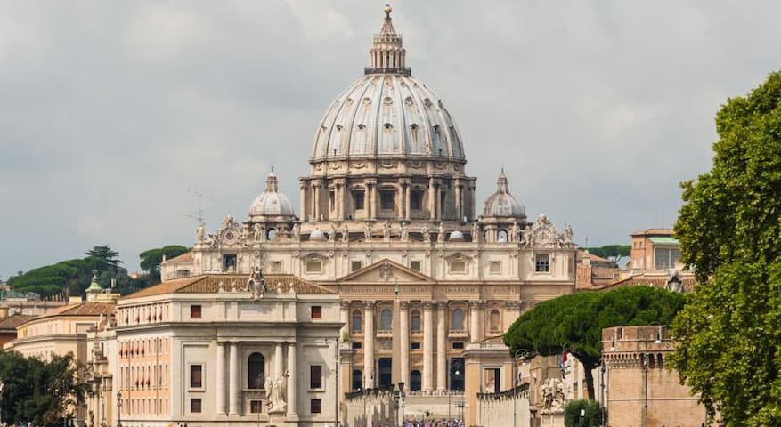
The basilica of St. Peter in the Vatican, officially the papal major basilica of St. Peter in the Vatican, is a Catholic basilica in the Vatican City; symbol of the Vatican State, crowned by the monumental Piazza San Pietro.
It is the largest of the four papal basilicas of Rome [1] and is often described as the largest church in the world both for its size and, metaphorically, for its importance as a center of Catholicism [2]. However, it is not the cathedral church of the Roman diocese since this title belongs to the basilica of San Giovanni in Laterano, which is also the first in dignity as it is the Mother and Head of all the Churches of the City and of the World.
As the papal chapel, located adjacent to the Apostolic Palace, the basilica of San Pietro is the seat of the main manifestations of Catholic worship and is therefore in solemn function on the occasion of the main papal celebrations. Under the pontificate of Pius IX it hosted the sessions of the First Vatican Council and under Pope John XXIII and Paul VI those of the Second Vatican Council.
In addition to its liturgical importance, due to its millennial history, the workers involved, the exceptional technical and artistic quality, as well as the enormous and lasting influence exerted on subsequent architecture, St. Peter's Basilica is widely considered one of the absolute masterpieces. and one of the most important achievements in the history of architecture, and is included in the UNESCO World Heritage Site called Vatican City and established in 1984.
The construction of the current St. Peter's Basilica was begun on April 18, 1506 under Pope Julius II and ended in 1626, during the pontificate of Pope Urban VIII, while the arrangement of the square in front was only completed in 1667.
59 paikallista suosittelee
St. Peter's Basilica
Piazza San PietroThe basilica of St. Peter in the Vatican, officially the papal major basilica of St. Peter in the Vatican, is a Catholic basilica in the Vatican City; symbol of the Vatican State, crowned by the monumental Piazza San Pietro.
It is the largest of the four papal basilicas of Rome [1] and is often described as the largest church in the world both for its size and, metaphorically, for its importance as a center of Catholicism [2]. However, it is not the cathedral church of the Roman diocese since this title belongs to the basilica of San Giovanni in Laterano, which is also the first in dignity as it is the Mother and Head of all the Churches of the City and of the World.
As the papal chapel, located adjacent to the Apostolic Palace, the basilica of San Pietro is the seat of the main manifestations of Catholic worship and is therefore in solemn function on the occasion of the main papal celebrations. Under the pontificate of Pius IX it hosted the sessions of the First Vatican Council and under Pope John XXIII and Paul VI those of the Second Vatican Council.
In addition to its liturgical importance, due to its millennial history, the workers involved, the exceptional technical and artistic quality, as well as the enormous and lasting influence exerted on subsequent architecture, St. Peter's Basilica is widely considered one of the absolute masterpieces. and one of the most important achievements in the history of architecture, and is included in the UNESCO World Heritage Site called Vatican City and established in 1984.
The construction of the current St. Peter's Basilica was begun on April 18, 1506 under Pope Julius II and ended in 1626, during the pontificate of Pope Urban VIII, while the arrangement of the square in front was only completed in 1667.
The Vatican Museums are the national museum of the Vatican City, in Rome.
Founded by Pope Julius II in the 16th century, they occupy a large part of the vast courtyard of the Belvedere and are one of the largest art collections in the world, since they exhibit the enormous collection of works of art accumulated over the centuries by popes: the Sistine Chapel and the papal apartments frescoed by Michelangelo and Raphael are part of the works that visitors can admire on their way. Although the museums are located entirely in Vatican territory, their entrance is located in Italian territory, in viale Vaticano 6 in Rome.
The museum has an average annual turnout of around six and a half million visitors from all over the world.
1756 paikallista suosittelee
Vatikaanin museot
The Vatican Museums are the national museum of the Vatican City, in Rome.
Founded by Pope Julius II in the 16th century, they occupy a large part of the vast courtyard of the Belvedere and are one of the largest art collections in the world, since they exhibit the enormous collection of works of art accumulated over the centuries by popes: the Sistine Chapel and the papal apartments frescoed by Michelangelo and Raphael are part of the works that visitors can admire on their way. Although the museums are located entirely in Vatican territory, their entrance is located in Italian territory, in viale Vaticano 6 in Rome.
The museum has an average annual turnout of around six and a half million visitors from all over the world.
Castel Sant'Angelo (or Mole Adrianorum or Castellum Crescentii in the 10th-12th century), also known as the Mausoleum of Hadrian, is a monument of Rome, located on the right bank of the Tiber in front of the pons Aelius (current Sant'Angelo bridge), a short distance from the Vatican, between the Borgo and Prati districts; it is connected to the Vatican State through the fortified corridor of the "passetto".
The castle has been radically modified several times in the Middle Ages and the Renaissance.
1219 paikallista suosittelee

Castel Sant'Angelo
50 Lungotevere CastelloCastel Sant'Angelo (or Mole Adrianorum or Castellum Crescentii in the 10th-12th century), also known as the Mausoleum of Hadrian, is a monument of Rome, located on the right bank of the Tiber in front of the pons Aelius (current Sant'Angelo bridge), a short distance from the Vatican, between the Borgo and Prati districts; it is connected to the Vatican State through the fortified corridor of the "passetto".
The castle has been radically modified several times in the Middle Ages and the Renaissance.
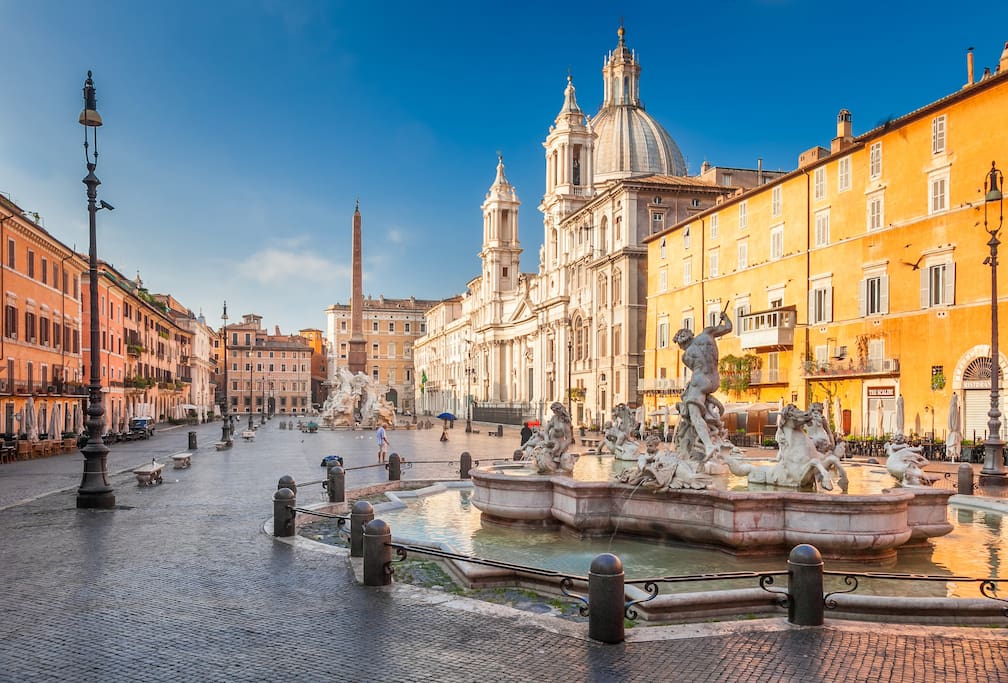
Piazza Navona is one of the most famous monumental squares in Rome, built in monumental style by the Pamphili family at the behest of Pope Innocent X (Giovanni Battista Pamphili) with the typical shape of an ancient stadium.
Is a symbol of Baroque Rome, with architectural and sculptural elements by Gian Lorenzo Bernini (the Fountain of the Four Rivers in the center of the square, which represents the Danube, the Ganges, the Nile and the Rio della Plata, the four corners of the earth), Francesco Borromini and Girolamo Rainaldi (the church of Sant'Agnese in Agone, in front of the Bernini fountain).
1722 paikallista suosittelee
Piazza Navona
Piazza NavonaPiazza Navona is one of the most famous monumental squares in Rome, built in monumental style by the Pamphili family at the behest of Pope Innocent X (Giovanni Battista Pamphili) with the typical shape of an ancient stadium.
Is a symbol of Baroque Rome, with architectural and sculptural elements by Gian Lorenzo Bernini (the Fountain of the Four Rivers in the center of the square, which represents the Danube, the Ganges, the Nile and the Rio della Plata, the four corners of the earth), Francesco Borromini and Girolamo Rainaldi (the church of Sant'Agnese in Agone, in front of the Bernini fountain).
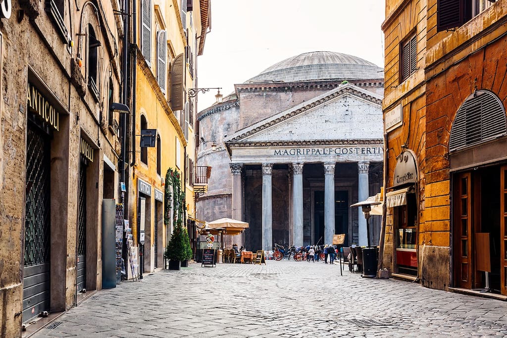
The Pantheon (in ancient Greek: Πάνθεων [ἱερόν], Pántheon [hierón], "[temple] of all the gods"), in classical Latin Pantheum, is a building of ancient Rome located in the Pigna district in the historic center, built as a temple dedicated to all past, present and future deities. It was founded in 27 BC. from the harpinate Marco Vipsanio Agrippa, son-in-law of Augustus. It was rebuilt by the emperor Hadrian presumably from 112-115 until 124 AD. circa, after the fires of 80 and 110 AD they had damaged the previous construction of the Augustan age.
It is composed of a circular structure joined to a pronaos in Corinthian columns (eight at the front and two groups of four in the second and third row) that support a pediment. The large circular cell, called rotunda, is surrounded by thick masonry walls and eight large pylons on which the weight of the characteristic hemispherical concrete dome is distributed, which houses at its apex a circular opening called oculus, which allows the illumination of the internal environment. The height of the building calculated at the oculus is equal to the diameter of the rotunda, a feature that reflects the classical criteria of balanced and harmonious architecture. Almost two millennia after its construction, the intrados dome of the Pantheon is still today one of the largest domes in the world, and specifically the largest built in Roman concrete.
At the beginning of the 7th century the Pantheon was converted into a Christian basilica called Santa Maria della Rotonda or Santa Maria ad Martyres, which allowed it to survive almost intact the looting inflicted by the popes on the buildings of classical Rome. It enjoys the rank of minor basilica and is the only basilica in Rome besides the patriarchal ones to still have a chapter. The inhabitants of Rome popularly called it the Rotonna ("the Rotonda"), from which the name of the square and the street in front of it derive.
1342 paikallista suosittelee
Pantheon
Piazza della RotondaThe Pantheon (in ancient Greek: Πάνθεων [ἱερόν], Pántheon [hierón], "[temple] of all the gods"), in classical Latin Pantheum, is a building of ancient Rome located in the Pigna district in the historic center, built as a temple dedicated to all past, present and future deities. It was founded in 27 BC. from the harpinate Marco Vipsanio Agrippa, son-in-law of Augustus. It was rebuilt by the emperor Hadrian presumably from 112-115 until 124 AD. circa, after the fires of 80 and 110 AD they had damaged the previous construction of the Augustan age.
It is composed of a circular structure joined to a pronaos in Corinthian columns (eight at the front and two groups of four in the second and third row) that support a pediment. The large circular cell, called rotunda, is surrounded by thick masonry walls and eight large pylons on which the weight of the characteristic hemispherical concrete dome is distributed, which houses at its apex a circular opening called oculus, which allows the illumination of the internal environment. The height of the building calculated at the oculus is equal to the diameter of the rotunda, a feature that reflects the classical criteria of balanced and harmonious architecture. Almost two millennia after its construction, the intrados dome of the Pantheon is still today one of the largest domes in the world, and specifically the largest built in Roman concrete.
At the beginning of the 7th century the Pantheon was converted into a Christian basilica called Santa Maria della Rotonda or Santa Maria ad Martyres, which allowed it to survive almost intact the looting inflicted by the popes on the buildings of classical Rome. It enjoys the rank of minor basilica and is the only basilica in Rome besides the patriarchal ones to still have a chapter. The inhabitants of Rome popularly called it the Rotonna ("the Rotonda"), from which the name of the square and the street in front of it derive.
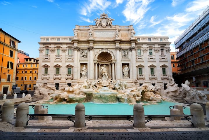
The Trevi Fountain is the largest of the famous fountains in Rome.
Built on the facade of Palazzo Poli by Nicola Salvi, the competition launched by Pope Clement XII in 1731 was initially won by the French sculptor Lambert-Sigisbert Adam but later the assignment passed to Salvi: it is said that the change was due to the fact that the pontiff did not want to entrust the work to a foreigner, instead another version explains that Adam had to return to France.
Begun in 1732, it was finally entrusted in 1759 to Pietro Bracci helped by his son Virginio. The two completed the work, which was inaugurated in 1762.
1461 paikallista suosittelee
Trevin suihkulähde
Piazza di TreviThe Trevi Fountain is the largest of the famous fountains in Rome.
Built on the facade of Palazzo Poli by Nicola Salvi, the competition launched by Pope Clement XII in 1731 was initially won by the French sculptor Lambert-Sigisbert Adam but later the assignment passed to Salvi: it is said that the change was due to the fact that the pontiff did not want to entrust the work to a foreigner, instead another version explains that Adam had to return to France.
Begun in 1732, it was finally entrusted in 1759 to Pietro Bracci helped by his son Virginio. The two completed the work, which was inaugurated in 1762.
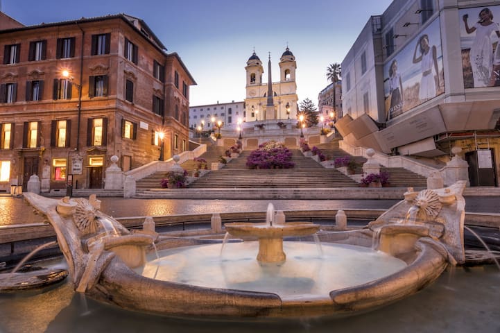
Piazza di Spagna, with the Spanish Steps, is one of the most famous in Rome. It owes its name to the palace of Spain, seat of the Iberian state embassy to the Holy See.
In the center of the square there is the famous Barcaccia fountain, which dates back to the early Baroque period, built by Pietro Bernini and his son, the most famous Gian Lorenzo.
On the side of via Frattina stands the Palazzo di Propaganda Fide, owned by the Holy See. In front of its facade, designed by Bernini (while the side facade is instead by Francesco Borromini), stands the column of the Immaculate Conception, which was raised after the proclamation of the dogma by the will of King Ferdinand II of the Two Sicilies in thanks for one escaped attack, and inaugurated on December 8, 1857. Since 1923 the Fire Brigade has been offering an acrobatic floral tribute to the statue, using their stairs; in 1953 Pope Pius XII himself wanted to attend the ceremony, but it was from 1958 with John XXIII that the presence of the Holy Father at this rite became a real tradition, faithfully maintained by all the popes.
The monumental staircase of 135 steps, commissioned by Cardinal Pierre Guérin de Tencin, was inaugurated by Pope Benedict XIII on the occasion of the Jubilee of 1725: it was built, thanks to French funding starting from 1721, to connect the embassy of the Bourbons of Spain, to which the square owes its name, to the church of the Trinità dei Monti.
It was designed by both Alessandro Specchi and Francesco De Sanctis after generations of long and heated discussions on how the steep slope on the side of the Pincio should be urbanized to connect it to the church. The solution chosen was that of De Sanctis: a large staircase decorated with numerous garden terraces, which in spring and summer is beautifully decorated with many flowers. The sumptuous, aristocratic staircase, located at the apex of a long road axis that led to the Tiber, was designed so that the scenic effects gradually increased as you approached. Typical of the great Baroque architecture was in fact the creation of long, deep perspectives culminating with scenes or backgrounds of a monumental nature.
1307 paikallista suosittelee
Piazza di Spagna
Piazza di SpagnaPiazza di Spagna, with the Spanish Steps, is one of the most famous in Rome. It owes its name to the palace of Spain, seat of the Iberian state embassy to the Holy See.
In the center of the square there is the famous Barcaccia fountain, which dates back to the early Baroque period, built by Pietro Bernini and his son, the most famous Gian Lorenzo.
On the side of via Frattina stands the Palazzo di Propaganda Fide, owned by the Holy See. In front of its facade, designed by Bernini (while the side facade is instead by Francesco Borromini), stands the column of the Immaculate Conception, which was raised after the proclamation of the dogma by the will of King Ferdinand II of the Two Sicilies in thanks for one escaped attack, and inaugurated on December 8, 1857. Since 1923 the Fire Brigade has been offering an acrobatic floral tribute to the statue, using their stairs; in 1953 Pope Pius XII himself wanted to attend the ceremony, but it was from 1958 with John XXIII that the presence of the Holy Father at this rite became a real tradition, faithfully maintained by all the popes.
The monumental staircase of 135 steps, commissioned by Cardinal Pierre Guérin de Tencin, was inaugurated by Pope Benedict XIII on the occasion of the Jubilee of 1725: it was built, thanks to French funding starting from 1721, to connect the embassy of the Bourbons of Spain, to which the square owes its name, to the church of the Trinità dei Monti.
It was designed by both Alessandro Specchi and Francesco De Sanctis after generations of long and heated discussions on how the steep slope on the side of the Pincio should be urbanized to connect it to the church. The solution chosen was that of De Sanctis: a large staircase decorated with numerous garden terraces, which in spring and summer is beautifully decorated with many flowers. The sumptuous, aristocratic staircase, located at the apex of a long road axis that led to the Tiber, was designed so that the scenic effects gradually increased as you approached. Typical of the great Baroque architecture was in fact the creation of long, deep perspectives culminating with scenes or backgrounds of a monumental nature.
Piazza del Popolo is one of the most famous squares in Rome, at the foot of the Pincio.
The origin of the name of the square is uncertain: there is an etymology that derives "people" from the Latin populus (poplar), based on the tradition that there was, in the area, a grove of poplars pertaining to the tomb of Nero, which was there near. It is historical news, however, that Pope Paschal II had a chapel built close to the walls, at the expense of the Roman people (the one on which the current church of Santa Maria del Popolo would later rise): the Madonna was of the people, the People became the square.
797 paikallista suosittelee
Piazza del Popolo
Piazza del PopoloPiazza del Popolo is one of the most famous squares in Rome, at the foot of the Pincio.
The origin of the name of the square is uncertain: there is an etymology that derives "people" from the Latin populus (poplar), based on the tradition that there was, in the area, a grove of poplars pertaining to the tomb of Nero, which was there near. It is historical news, however, that Pope Paschal II had a chapel built close to the walls, at the expense of the Roman people (the one on which the current church of Santa Maria del Popolo would later rise): the Madonna was of the people, the People became the square.
The Pincio promenade, located between Piazza del Popolo, Villa Medici and the Muro Torto, with a direct connection to Villa Borghese through via delle Magnolie, was conceived by the Napoleonic administration, established in Rome since 1810, to meet multiple needs of an urban nature. and social.
Completed between 1811 and 1823, the Promenade was, until the mid-twentieth century, the real city park, the urban promenade, the garden of the Roman people who were able to enjoy countless events and shows, from pyrotechnic pinwheels and from the concerts of the band of maestro Alessandro Vessella, at the turn of the nineteenth and twentieth centuries, up to today's musical events. Even today it is a destination for walks and the Napoleon square, which overlooks Piazza del Popolo, is a favorite place for Romans and tourists.
259 paikallista suosittelee
Pincio Promenade
Viale Gabriele D'AnnunzioThe Pincio promenade, located between Piazza del Popolo, Villa Medici and the Muro Torto, with a direct connection to Villa Borghese through via delle Magnolie, was conceived by the Napoleonic administration, established in Rome since 1810, to meet multiple needs of an urban nature. and social.
Completed between 1811 and 1823, the Promenade was, until the mid-twentieth century, the real city park, the urban promenade, the garden of the Roman people who were able to enjoy countless events and shows, from pyrotechnic pinwheels and from the concerts of the band of maestro Alessandro Vessella, at the turn of the nineteenth and twentieth centuries, up to today's musical events. Even today it is a destination for walks and the Napoleon square, which overlooks Piazza del Popolo, is a favorite place for Romans and tourists.
The church of San Luigi dei Francesi is a Catholic place of worship in Rome overlooking the square of the same name, not far from Piazza Navona, in the Sant'Eustachio district. It has been the national church of the French in Rome since 1589.
The works were carried out by Domenico Fontana on designs by Giacomo Della Porta, and thanks to the munificence of Caterina de 'Medici, from 1518 to 1589, and the church was consecrated on 8 October 1589. In 1749 the interiors were renovated under the design of the French architect Antoine Dérizet; these works continued until 1764.
Although consecrated to the Virgin Mary, to Saint Dionysius the Areopagite and to King Saint Louis IX, it is known above all by the latter name. From the beginning of its construction it was erected as a parish for the French residents of the city; it is also the seat of the cardinal title of San Luigi dei Francesi.
150 paikallista suosittelee
Church of St. Louis of the French
Piazza di San Luigi de' FrancesiThe church of San Luigi dei Francesi is a Catholic place of worship in Rome overlooking the square of the same name, not far from Piazza Navona, in the Sant'Eustachio district. It has been the national church of the French in Rome since 1589.
The works were carried out by Domenico Fontana on designs by Giacomo Della Porta, and thanks to the munificence of Caterina de 'Medici, from 1518 to 1589, and the church was consecrated on 8 October 1589. In 1749 the interiors were renovated under the design of the French architect Antoine Dérizet; these works continued until 1764.
Although consecrated to the Virgin Mary, to Saint Dionysius the Areopagite and to King Saint Louis IX, it is known above all by the latter name. From the beginning of its construction it was erected as a parish for the French residents of the city; it is also the seat of the cardinal title of San Luigi dei Francesi.
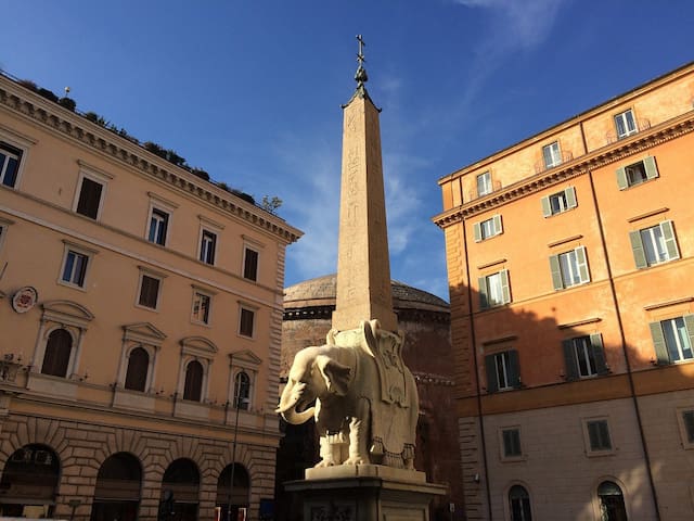
Piazza della Minerva is a square in the historic center of Rome, in the Pigna district, located near the Pantheon.
The name of the square derives from the original existence in this place of a temple built by Gneo Pompeo Magno and dedicated to Minerva Chalkidiki, whose cult statue is now in the Vatican.
The basilica of Santa Maria sopra Minerva, center of gravity of the entire square, was already mentioned in the 8th century by the Anonymous of Einsiedeln with the name of (ecclesia) "S. Mariae in Minervio".
To the right of the façade there are various tombstones that commemorate the height reached by the floods of the Tiber between 1422 and 1598: the area is in fact among the lowest in Rome, and once the river had overflowed it took quite a while. of time for it to dry.
A vast convent, the "professed" house built next to the church when it became the seat of the Dominicans between 1266 and 1275, which in the 17th century became the seat of the Roman Inquisition or Sant'Uffizio (the trial of Galileo Galilei was celebrated there in 1633 and pronounced his abjuration).
At the center of the square, since 1667, the obelisk of the Minerva has been positioned on the back of a small marble elephant sculpted by Bernini which turns its back on the convent of the Inquisition. The obelisk, coming from the Iseum, was brought to light during excavations carried out in the cloister. The elephant is known as "the Minerva's pulcin".
7 paikallista suosittelee
Piazza della Minerva
Piazza della Minerva is a square in the historic center of Rome, in the Pigna district, located near the Pantheon.
The name of the square derives from the original existence in this place of a temple built by Gneo Pompeo Magno and dedicated to Minerva Chalkidiki, whose cult statue is now in the Vatican.
The basilica of Santa Maria sopra Minerva, center of gravity of the entire square, was already mentioned in the 8th century by the Anonymous of Einsiedeln with the name of (ecclesia) "S. Mariae in Minervio".
To the right of the façade there are various tombstones that commemorate the height reached by the floods of the Tiber between 1422 and 1598: the area is in fact among the lowest in Rome, and once the river had overflowed it took quite a while. of time for it to dry.
A vast convent, the "professed" house built next to the church when it became the seat of the Dominicans between 1266 and 1275, which in the 17th century became the seat of the Roman Inquisition or Sant'Uffizio (the trial of Galileo Galilei was celebrated there in 1633 and pronounced his abjuration).
At the center of the square, since 1667, the obelisk of the Minerva has been positioned on the back of a small marble elephant sculpted by Bernini which turns its back on the convent of the Inquisition. The obelisk, coming from the Iseum, was brought to light during excavations carried out in the cloister. The elephant is known as "the Minerva's pulcin".
Campo de 'Fiori is a square in Rome, between via dei Giubbonari and piazza della Cancelleria, on the border of the Parione and Regola districts. Until the fifteenth century the square did not exist as such, and in its place there was a flowery meadow with some cultivated gardens, hence the name. According to an unreliable tradition, the square should instead be named after Flora (a woman loved by Pompeo, who had built her theater near her).
The square reached its current extension after 1858 when the existing houses on the north side between via dei Baullari and vicolo del Gallo were demolished, moving the copy of the Terrina fountain, previously placed in the center of the square, to the new recovered area.
In Campo de 'Fiori the executions and punishments with stretches of rope took place. On Thursday 17 February 1600 the Dominican philosopher and friar Giordano Bruno was burned alive there, accused of heresy.
Since 1869 the square has been home to a lively and picturesque market, whose popular atmosphere is well rendered by the well-known 1943 film Campo de 'Fiori, starring Anna Magnani and Aldo Fabrizi.
Campo de 'Fiori is the only historic square in Rome where there is no church.
54 paikallista suosittelee
Campo de' Fiori
Campo de' FioriCampo de 'Fiori is a square in Rome, between via dei Giubbonari and piazza della Cancelleria, on the border of the Parione and Regola districts. Until the fifteenth century the square did not exist as such, and in its place there was a flowery meadow with some cultivated gardens, hence the name. According to an unreliable tradition, the square should instead be named after Flora (a woman loved by Pompeo, who had built her theater near her).
The square reached its current extension after 1858 when the existing houses on the north side between via dei Baullari and vicolo del Gallo were demolished, moving the copy of the Terrina fountain, previously placed in the center of the square, to the new recovered area.
In Campo de 'Fiori the executions and punishments with stretches of rope took place. On Thursday 17 February 1600 the Dominican philosopher and friar Giordano Bruno was burned alive there, accused of heresy.
Since 1869 the square has been home to a lively and picturesque market, whose popular atmosphere is well rendered by the well-known 1943 film Campo de 'Fiori, starring Anna Magnani and Aldo Fabrizi.
Campo de 'Fiori is the only historic square in Rome where there is no church.
Largo di Torre Argentina is a square in the historic center of Rome. At its center is an archaeological area with the remains of four Roman temples dating back to the Republican age.
The square as it appears today was obtained between 1926 and 1929, by demolishing a pre-existing block of medieval origin.
The destination of the area as an archaeological area was in doubt until it was decided, following a plea sent by the archaeologist Giuseppe Marchetti Longhi directly to Benito Mussolini, to arrange the area to constitute the so-called Foro Argentina, inaugurated by the Duce in April of 1929.
In the square therefore remains the Torre del Papito now isolated from the original urban context, as well as the famous Teatro Argentina, built in 1732 by Duke Giuseppe Cesarini Sforza.
192 paikallista suosittelee
Largo di Torre Argentina
Largo di Torre ArgentinaLargo di Torre Argentina is a square in the historic center of Rome. At its center is an archaeological area with the remains of four Roman temples dating back to the Republican age.
The square as it appears today was obtained between 1926 and 1929, by demolishing a pre-existing block of medieval origin.
The destination of the area as an archaeological area was in doubt until it was decided, following a plea sent by the archaeologist Giuseppe Marchetti Longhi directly to Benito Mussolini, to arrange the area to constitute the so-called Foro Argentina, inaugurated by the Duce in April of 1929.
In the square therefore remains the Torre del Papito now isolated from the original urban context, as well as the famous Teatro Argentina, built in 1732 by Duke Giuseppe Cesarini Sforza.
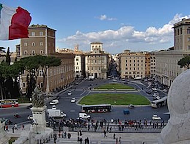
Piazza Venezia is a famous square in Rome. It is located at the foot of the Campidoglio, where five of the most important streets of the capital cross: via dei Fori Imperiali, via del Corso, the via C. Battisti-via Nazionale axis, the via del Plebiscito-corso Vittorio axis and via of the Theater of Marcellus.
The square is dominated by the Altare della Patria, one of the Italian patriotic symbols; three monumental palaces surround it on the other sides. The oldest is the fifteenth-century Palazzo Venezia, which gives its name to the square and which is the seat of the national museum of the same name. The other buildings are the seventeenth-century Palazzo Bonaparte and the Palazzo delle Assicurazioni Generali, built in the early years of the twentieth century.
The boundaries of three districts meet on Piazza Venezia: the Pigna district extends to the west of it, the Trevi district to the east and the Campitelli district to the south.
The five important streets that branch off from Piazza Venezia make it a fundamental node of the urban fabric. The oldest is the very central Via del Corso, which connects the square with the northern area of the capital. The route of Via del Corso dates back to 220 BC, following that of the urban stretch of the Via Flaminia, one of the most important consular roads.
In the post-unification period, two new roads converging on the square were traced. In 1879 Via Nazionale was opened, to connect the center with the Termini Station area and with the eastern districts of the city; the axis of via Nazionale reaches the square through via Cesare Battisti. During the same period, Corso Vittorio was also opened, leading to the Vatican and the north-western districts; this course reaches the square through the short via del Plebiscito.
During the Fascist period, two other roads of great urban communication were opened, starting from Piazza Venezia. Via del Teatro di Marcello, opened in 1927, connects the square with the Tiber and constituted the first stretch of the Via del Mare, directed towards the south-western districts, the EUR and the coast of Ostia. In 1933 Via dell'Impero was opened, today Via dei Fori Imperiali, directed towards the Colosseum, the Lateran and the south-eastern districts. With the opening of the new four streets, Piazza Venezia found itself assuming the current role of communication ganglion between the various parts of the capital.
576 paikallista suosittelee
Piazza Venezia
Piazza Venezia is a famous square in Rome. It is located at the foot of the Campidoglio, where five of the most important streets of the capital cross: via dei Fori Imperiali, via del Corso, the via C. Battisti-via Nazionale axis, the via del Plebiscito-corso Vittorio axis and via of the Theater of Marcellus.
The square is dominated by the Altare della Patria, one of the Italian patriotic symbols; three monumental palaces surround it on the other sides. The oldest is the fifteenth-century Palazzo Venezia, which gives its name to the square and which is the seat of the national museum of the same name. The other buildings are the seventeenth-century Palazzo Bonaparte and the Palazzo delle Assicurazioni Generali, built in the early years of the twentieth century.
The boundaries of three districts meet on Piazza Venezia: the Pigna district extends to the west of it, the Trevi district to the east and the Campitelli district to the south.
The five important streets that branch off from Piazza Venezia make it a fundamental node of the urban fabric. The oldest is the very central Via del Corso, which connects the square with the northern area of the capital. The route of Via del Corso dates back to 220 BC, following that of the urban stretch of the Via Flaminia, one of the most important consular roads.
In the post-unification period, two new roads converging on the square were traced. In 1879 Via Nazionale was opened, to connect the center with the Termini Station area and with the eastern districts of the city; the axis of via Nazionale reaches the square through via Cesare Battisti. During the same period, Corso Vittorio was also opened, leading to the Vatican and the north-western districts; this course reaches the square through the short via del Plebiscito.
During the Fascist period, two other roads of great urban communication were opened, starting from Piazza Venezia. Via del Teatro di Marcello, opened in 1927, connects the square with the Tiber and constituted the first stretch of the Via del Mare, directed towards the south-western districts, the EUR and the coast of Ostia. In 1933 Via dell'Impero was opened, today Via dei Fori Imperiali, directed towards the Colosseum, the Lateran and the south-eastern districts. With the opening of the new four streets, Piazza Venezia found itself assuming the current role of communication ganglion between the various parts of the capital.
The National Monument to Vittorio Emanuele II or (mole del) Vittoriano, called by synecdoche Altare della Patria, is an Italian national monument located in Rome, in Piazza Venezia, on the northern slope of the Campidoglio hill, the work of the architect Giuseppe Sacconi. It is located in the center of ancient Rome and connected to modern Rome thanks to roads that radiate off from Piazza Venezia.
Its construction began in 1885 and the works ended in 1935: however, already in 1911, the monument was officially inaugurated and opened to the public, on the occasion of the celebrations of the 50th anniversary of the unification of Italy. From an architectural point of view it was conceived as a modern forum, an agora on three levels connected by stairways and topped by a portico characterized by a colonnade.
It has a great representative value, being architecturally and artistically centered on the Risorgimento, the complex process of national unity and liberation from foreign domination carried out under the reign of Vittorio Emanuele II of Savoy, to whom the monument is dedicated: for this reason the Vittoriano is considered one of the Italian patri symbols. The Vittoriano contains the Altare della Patria, first an altar of the goddess Rome and then, since 1921, also the chapel of the Unknown Soldier. Since this element is perceived as the emblematic center of the building, the whole monument is often called the Altare della Patria.
Since its inauguration it has been the scene of important celebratory moments. This has accentuated its role as a symbol of national identity. The most important celebrations that take place at the Vittoriano take place annually on the occasion of the Anniversary of the liberation of Italy (25 April), the Italian Republic Day (2 June) and the Day of National Unity and the Armed Forces (4 November ), during which the President of the Italian Republic and the highest offices of the State pay homage to the chapel of the Unknown Soldier by placing a laurel wreath in memory of the fallen and missing Italians in the wars.
The monument has a wide symbolic value representing - thanks to the recall of the figure of Vittorio Emanuele II and the construction of the Altare della Patria - a secular temple metaphorically dedicated to free and united Italy and celebrating - by virtue of the burial of the Soldier - the sacrifice for the homeland and the associated ideals.
337 paikallista suosittelee
Isänmaan alttari
Piazza VeneziaThe National Monument to Vittorio Emanuele II or (mole del) Vittoriano, called by synecdoche Altare della Patria, is an Italian national monument located in Rome, in Piazza Venezia, on the northern slope of the Campidoglio hill, the work of the architect Giuseppe Sacconi. It is located in the center of ancient Rome and connected to modern Rome thanks to roads that radiate off from Piazza Venezia.
Its construction began in 1885 and the works ended in 1935: however, already in 1911, the monument was officially inaugurated and opened to the public, on the occasion of the celebrations of the 50th anniversary of the unification of Italy. From an architectural point of view it was conceived as a modern forum, an agora on three levels connected by stairways and topped by a portico characterized by a colonnade.
It has a great representative value, being architecturally and artistically centered on the Risorgimento, the complex process of national unity and liberation from foreign domination carried out under the reign of Vittorio Emanuele II of Savoy, to whom the monument is dedicated: for this reason the Vittoriano is considered one of the Italian patri symbols. The Vittoriano contains the Altare della Patria, first an altar of the goddess Rome and then, since 1921, also the chapel of the Unknown Soldier. Since this element is perceived as the emblematic center of the building, the whole monument is often called the Altare della Patria.
Since its inauguration it has been the scene of important celebratory moments. This has accentuated its role as a symbol of national identity. The most important celebrations that take place at the Vittoriano take place annually on the occasion of the Anniversary of the liberation of Italy (25 April), the Italian Republic Day (2 June) and the Day of National Unity and the Armed Forces (4 November ), during which the President of the Italian Republic and the highest offices of the State pay homage to the chapel of the Unknown Soldier by placing a laurel wreath in memory of the fallen and missing Italians in the wars.
The monument has a wide symbolic value representing - thanks to the recall of the figure of Vittorio Emanuele II and the construction of the Altare della Patria - a secular temple metaphorically dedicated to free and united Italy and celebrating - by virtue of the burial of the Soldier - the sacrifice for the homeland and the associated ideals.
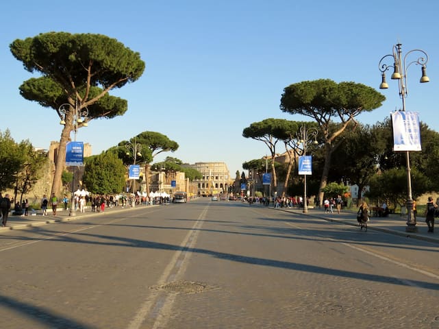
Via dei Fori Imperiali is one of the most scenic streets in Rome; opened in 1932 with the name of via dell'Impero, it takes its current name from the monumental remains of the forums of Caesar, Augustus, Nerva, della Pace and Traiano that can be admired by walking along it. It connects Piazza Venezia with the Colosseum, which constitutes its visual goal. It is lined with domestic pines, the characteristic "pines of Rome".
In addition to the Imperial Forums, the street overlooks other famous Roman monuments: the Basilica of Maxentius, the Roman Forum, the Trajan's Markets, the Militia tower, the House of the Knights of Rhodes and the eastern side of the Vittoriano. Furthermore, the street leads to the basilica of Santi Cosma and Damiano and to the church of San Lorenzo in Miranda, which reuse, respectively, the structures of the temple of the Divine Romulus and of the temple of Antoninus and Faustina; about halfway along the road, the Tor de 'Conti rises.
Since 1950, the annual parade on 2 June has been held here on the occasion of the feast of the Italian Republic.
147 paikallista suosittelee
Via dei Fori Imperiali
Via dei Fori ImperialiVia dei Fori Imperiali is one of the most scenic streets in Rome; opened in 1932 with the name of via dell'Impero, it takes its current name from the monumental remains of the forums of Caesar, Augustus, Nerva, della Pace and Traiano that can be admired by walking along it. It connects Piazza Venezia with the Colosseum, which constitutes its visual goal. It is lined with domestic pines, the characteristic "pines of Rome".
In addition to the Imperial Forums, the street overlooks other famous Roman monuments: the Basilica of Maxentius, the Roman Forum, the Trajan's Markets, the Militia tower, the House of the Knights of Rhodes and the eastern side of the Vittoriano. Furthermore, the street leads to the basilica of Santi Cosma and Damiano and to the church of San Lorenzo in Miranda, which reuse, respectively, the structures of the temple of the Divine Romulus and of the temple of Antoninus and Faustina; about halfway along the road, the Tor de 'Conti rises.
Since 1950, the annual parade on 2 June has been held here on the occasion of the feast of the Italian Republic.
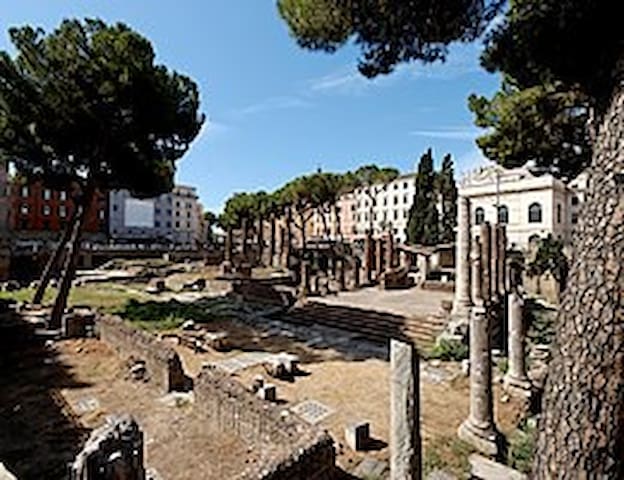
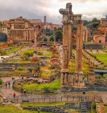
The Roman Forum (in Latin Forum Romanum, although the Romans referred to it more often as Forum Magnum or simply Forum) is an archaeological area of Rome enclosed between the Palatine Hill, the Campidoglio, Via dei Fori Imperiali and the Colosseum, consisting of the stratification of the remains of those buildings and monuments of heterogeneous eras that for much of the ancient history of Rome represented the political, legal, religious and economic center of the city of Rome, as well as the nerve center of the entire Roman civilization.
From the royal age to the advent of the medieval age, the valley of the Forum was the scene of events and the seat of institutions of such importance as to have repeatedly determined the historical course of Western civilization, and to have predominantly influenced the foundations political, legal, cultural and philosophical aspects of Western thought.
After a phase of decline that began in the late antiquity, the Forum was subject to frequent looting and changes of use until it found itself, in the sixteenth century, almost completely buried and permanently used as a pasture for cattle, hence the denomination of Campo Vaccine.
On the impulse of the reborn and growing interest in historical-archaeological studies of the late nineteenth century and also due to the massive urban restructuring of post-unification and fascist Italy, the area of the Forum was gradually brought to light and studied, becoming with the Colosseum and Palatine Hill one of the most famous and visited archaeological sites in the world.
33 paikallista suosittelee
Foro Romano
Foro RomanoThe Roman Forum (in Latin Forum Romanum, although the Romans referred to it more often as Forum Magnum or simply Forum) is an archaeological area of Rome enclosed between the Palatine Hill, the Campidoglio, Via dei Fori Imperiali and the Colosseum, consisting of the stratification of the remains of those buildings and monuments of heterogeneous eras that for much of the ancient history of Rome represented the political, legal, religious and economic center of the city of Rome, as well as the nerve center of the entire Roman civilization.
From the royal age to the advent of the medieval age, the valley of the Forum was the scene of events and the seat of institutions of such importance as to have repeatedly determined the historical course of Western civilization, and to have predominantly influenced the foundations political, legal, cultural and philosophical aspects of Western thought.
After a phase of decline that began in the late antiquity, the Forum was subject to frequent looting and changes of use until it found itself, in the sixteenth century, almost completely buried and permanently used as a pasture for cattle, hence the denomination of Campo Vaccine.
On the impulse of the reborn and growing interest in historical-archaeological studies of the late nineteenth century and also due to the massive urban restructuring of post-unification and fascist Italy, the area of the Forum was gradually brought to light and studied, becoming with the Colosseum and Palatine Hill one of the most famous and visited archaeological sites in the world.
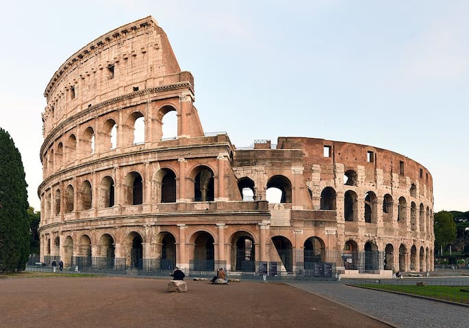
The Colosseum, originally known as the Flavian Amphitheater (in Latin: Amphitheatrum Flavium) or simply Amphitheatrum (in Italian: Anfiteatro), located in the center of the city of Rome, is the largest Roman amphitheater in the world (capable of holding a number of spectators estimated between 50,000 and 87,000). It is the most important Roman amphitheater, as well as the most imposing monument of ancient Rome that has come down to us.
Inserted in 1980 in the list of UNESCO World Heritage Sites - together with the entire historic center of Rome, the extraterritorial areas of the Holy See in Italy and the Basilica of San Paolo fuori le mura - in 2007, the only European monument, it was also included among the New Seven Wonders of the World following a competition organized by New Open World Corporation (NOWC).
The amphitheater was built in the Flavian period on an area on the eastern edge of the Roman Forum. Its construction, begun by Vespasian in 70 AD, was completed by Titus, who inaugurated it on 21 April in 80 AD. Further changes were made during Domitian's empire, in 90. The building forms an ellipse of 527 m in perimeter, with axes measuring 187.5 and 156.5 m. The arena inside measures 86 × 54 m, with an area of 3 357 m². The current height reaches 48.5 m, but originally reached 52 m. The structure clearly expresses the Roman architectural and construction concepts of the early Imperial Age, based respectively on the curved and enveloping line offered by the elliptical plan and on the complexity of the construction systems. Arches and vaults are linked together in a close structural relationship.
The name "Colosseum" spread only in the Middle Ages, and derives from the popular deformation of the Latin adjective "colosseum" (which can be translated into "colossal", as it appeared in the early Middle Ages among the one or two-storey houses) [3] or, more likely, from the proximity of the colossal acrolithic statue of Nero that stood nearby. [4] Soon the building became a symbol of the imperial city, an expression of an ideology in which the will to celebrate comes to define models for the leisure and entertainment of the people.
In ancient times it was used for gladiator shows and other public events (hunting shows, naval battles, reenactments of famous battles and dramas based on classical mythology). The tradition that wants it to be a place of martyrdom for Christians is unfounded [5]. No longer in use after the sixth century, the huge structure was reused over the centuries, even as a quarry for material. Today it is a symbol of the city of Rome and one of the major tourist attractions in the form of an archaeological monument that can be visited regularly.
2613 paikallista suosittelee
Colosseum
1 Piazza del ColosseoThe Colosseum, originally known as the Flavian Amphitheater (in Latin: Amphitheatrum Flavium) or simply Amphitheatrum (in Italian: Anfiteatro), located in the center of the city of Rome, is the largest Roman amphitheater in the world (capable of holding a number of spectators estimated between 50,000 and 87,000). It is the most important Roman amphitheater, as well as the most imposing monument of ancient Rome that has come down to us.
Inserted in 1980 in the list of UNESCO World Heritage Sites - together with the entire historic center of Rome, the extraterritorial areas of the Holy See in Italy and the Basilica of San Paolo fuori le mura - in 2007, the only European monument, it was also included among the New Seven Wonders of the World following a competition organized by New Open World Corporation (NOWC).
The amphitheater was built in the Flavian period on an area on the eastern edge of the Roman Forum. Its construction, begun by Vespasian in 70 AD, was completed by Titus, who inaugurated it on 21 April in 80 AD. Further changes were made during Domitian's empire, in 90. The building forms an ellipse of 527 m in perimeter, with axes measuring 187.5 and 156.5 m. The arena inside measures 86 × 54 m, with an area of 3 357 m². The current height reaches 48.5 m, but originally reached 52 m. The structure clearly expresses the Roman architectural and construction concepts of the early Imperial Age, based respectively on the curved and enveloping line offered by the elliptical plan and on the complexity of the construction systems. Arches and vaults are linked together in a close structural relationship.
The name "Colosseum" spread only in the Middle Ages, and derives from the popular deformation of the Latin adjective "colosseum" (which can be translated into "colossal", as it appeared in the early Middle Ages among the one or two-storey houses) [3] or, more likely, from the proximity of the colossal acrolithic statue of Nero that stood nearby. [4] Soon the building became a symbol of the imperial city, an expression of an ideology in which the will to celebrate comes to define models for the leisure and entertainment of the people.
In ancient times it was used for gladiator shows and other public events (hunting shows, naval battles, reenactments of famous battles and dramas based on classical mythology). The tradition that wants it to be a place of martyrdom for Christians is unfounded [5]. No longer in use after the sixth century, the huge structure was reused over the centuries, even as a quarry for material. Today it is a symbol of the city of Rome and one of the major tourist attractions in the form of an archaeological monument that can be visited regularly.
The Palatine Hill is one of the seven hills of Rome, located between the Velabro and the Roman Forum, and is one of the oldest parts of the city. The site is now a large open-air museum and can be visited during the day. The entrance is located in via di San Gregorio (entrance fee), or you can climb the Palatine Hill by entering the Roman Forum (entrance fee) and then climbing up Clivo Palatino, to the right of the Arch of Titus.
The Palatine is one of the central hills of Rome, but unlike the Capitol and the Aventine it is close to the river but not adjacent to it. The maximum height is 51 meters above sea level. The hill overlooks the Roman Forum on one side and the Circus Maximus on the other.
The Colle had two summits separated by a depression; the central summit, the highest, was called Palatium, while the other, located towards the slope that slopes down towards the Foro Boario and the Tiber, was called Germalus (or Cermalus).
It was once connected to the Esquiline behind it, through the Velia hill, excavated when the Via dei Fori Imperiali was built.
186 paikallista suosittelee
Palatine Hill
Via SacraThe Palatine Hill is one of the seven hills of Rome, located between the Velabro and the Roman Forum, and is one of the oldest parts of the city. The site is now a large open-air museum and can be visited during the day. The entrance is located in via di San Gregorio (entrance fee), or you can climb the Palatine Hill by entering the Roman Forum (entrance fee) and then climbing up Clivo Palatino, to the right of the Arch of Titus.
The Palatine is one of the central hills of Rome, but unlike the Capitol and the Aventine it is close to the river but not adjacent to it. The maximum height is 51 meters above sea level. The hill overlooks the Roman Forum on one side and the Circus Maximus on the other.
The Colle had two summits separated by a depression; the central summit, the highest, was called Palatium, while the other, located towards the slope that slopes down towards the Foro Boario and the Tiber, was called Germalus (or Cermalus).
It was once connected to the Esquiline behind it, through the Velia hill, excavated when the Via dei Fori Imperiali was built.
The Arch of Constantine is a triumphal arch with three arches (with a central passage flanked by two smaller side passages), located in Rome, a short distance from the Colosseum.
The Arch can be considered as a real official Roman sculpture museum, extraordinary for its richness and importance. The general dimensions of the elevation are 21 meters high, 25.9 meters wide and 7.4 meters deep.
The arch was dedicated by the senate to commemorate the victory of Constantine I against Maxentius in the battle of Ponte Milvio (28 October 312) and inaugurated in 315 on the occasion of the ten years of the emperor's reign; the location, between the Palatine and the Celio, was on the ancient route of the triumphs. The arch is one of the three surviving triumphal arches in Rome: the other two are the arch of Titus (c. 81–90) and the arch of Septimius Severus (202–203).
In 1530 Lorenzino de 'Medici was expelled from Rome for having cut off the heads on the reliefs of the arch for fun, which were partially reinstated in the 18th century.
In 1960, during the Games of the XVII Olympiad in Rome, the Arch of Constantine was the spectacular goal of the legendary marathon won barefoot by the Ethiopian Abebe Bikila.
57 paikallista suosittelee
Konstantinuksenkaari
Via di San GregorioThe Arch of Constantine is a triumphal arch with three arches (with a central passage flanked by two smaller side passages), located in Rome, a short distance from the Colosseum.
The Arch can be considered as a real official Roman sculpture museum, extraordinary for its richness and importance. The general dimensions of the elevation are 21 meters high, 25.9 meters wide and 7.4 meters deep.
The arch was dedicated by the senate to commemorate the victory of Constantine I against Maxentius in the battle of Ponte Milvio (28 October 312) and inaugurated in 315 on the occasion of the ten years of the emperor's reign; the location, between the Palatine and the Celio, was on the ancient route of the triumphs. The arch is one of the three surviving triumphal arches in Rome: the other two are the arch of Titus (c. 81–90) and the arch of Septimius Severus (202–203).
In 1530 Lorenzino de 'Medici was expelled from Rome for having cut off the heads on the reliefs of the arch for fun, which were partially reinstated in the 18th century.
In 1960, during the Games of the XVII Olympiad in Rome, the Arch of Constantine was the spectacular goal of the legendary marathon won barefoot by the Ethiopian Abebe Bikila.
The basilica of San Pietro in Vincoli is a place of Catholic worship in the historic center of Rome, located in the Monti district, on the Oppio hill; it is also called the Eudossian basilica from the name of the founder, Licinia Eudossia, the same one who called the Vandals who sacked it in 455 AD to Rome, and is known above all for hosting the tomb of Julius II with the famous Moses by Michelangelo Buonarroti.
The basilica is a rectory entrusted by the canons regular of the Lateran Congregation of the Most Holy Savior and the homonymous title of cardinal insists on it.
283 paikallista suosittelee
San Pietro in Vincoli
4/a Piazza di San Pietro in VincoliThe basilica of San Pietro in Vincoli is a place of Catholic worship in the historic center of Rome, located in the Monti district, on the Oppio hill; it is also called the Eudossian basilica from the name of the founder, Licinia Eudossia, the same one who called the Vandals who sacked it in 455 AD to Rome, and is known above all for hosting the tomb of Julius II with the famous Moses by Michelangelo Buonarroti.
The basilica is a rectory entrusted by the canons regular of the Lateran Congregation of the Most Holy Savior and the homonymous title of cardinal insists on it.
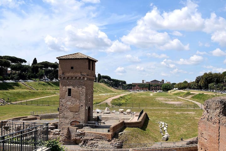
Circo Massimo is an ancient Roman circus located in Rome. Located in the valley between the Palatine and the Aventine, it is remembered as a venue for games since the beginning of the history of the city: the mythical episode of the rape of the Sabine women took place in the valley, on the occasion of the games organized by Romulus in honor of the god Consus. Certainly the large flat area and its proximity to the Tiber landing where trade took place from the remotest antiquity, meant that the place constituted since the foundation of the city the elective space in which to conduct market activities and exchanges with other populations, and - consequently - also the related ritual activities (think of the maximum altar of Hercules) and socialization, such as games and competitions.
34 paikallista suosittelee
Circus Maximus
Via del Circo MassimoCirco Massimo is an ancient Roman circus located in Rome. Located in the valley between the Palatine and the Aventine, it is remembered as a venue for games since the beginning of the history of the city: the mythical episode of the rape of the Sabine women took place in the valley, on the occasion of the games organized by Romulus in honor of the god Consus. Certainly the large flat area and its proximity to the Tiber landing where trade took place from the remotest antiquity, meant that the place constituted since the foundation of the city the elective space in which to conduct market activities and exchanges with other populations, and - consequently - also the related ritual activities (think of the maximum altar of Hercules) and socialization, such as games and competitions.
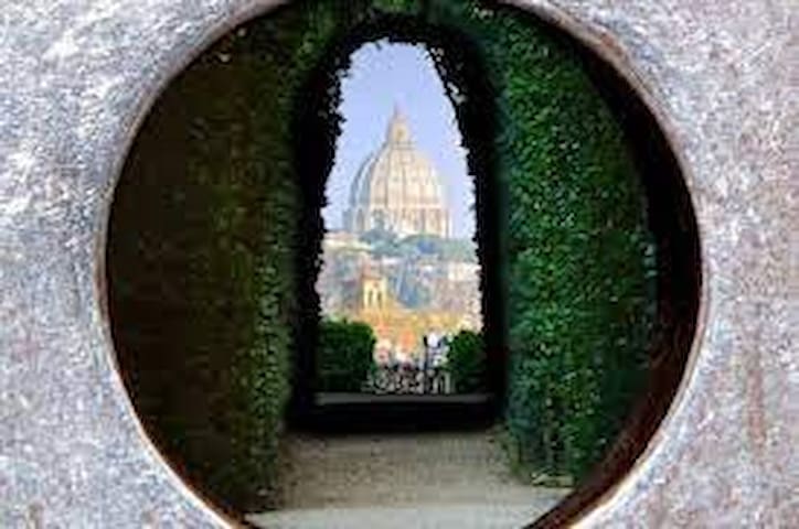
It is one of the most spectacular and unexpected views of the city and to be experienced in person to fully experience the surprise and excitement of stealing with your eyes a stunning and perspective view magically appearing behind a worn decorative brass hole open on the door.
The view is the result of an idea by Giovanni Battista Piranesi in 1765 but it is not yet known whether the perfect alignment of the keyhole and the dome of St. Peter's Basilica was a deliberate project or a lucky accident. However, when you witness the perfectly aligned foliage tunnel that leads your gaze directly to the Vatican City, it's hard to imagine that it was pure coincidence and it's nice to indulge in awe.
Furthermore, this is the only observation point where it is possible to enclose in a single glance three different states with their respective capitals: Vatican City in the distance, Rome and Italy all around and also the gardens of the Villa del Priorato of the Knights of Malta a sovereign entity belonging to Malta under international law.
This secret now known to many has become one of the most intriguing and off the beaten path places in the city, a favorite stop for travelers looking for alternative attractions willing to face the long line in front of the door to have a look and seize the moment to take a photo.
14 paikallista suosittelee
Knights of Malta Keyhole
It is one of the most spectacular and unexpected views of the city and to be experienced in person to fully experience the surprise and excitement of stealing with your eyes a stunning and perspective view magically appearing behind a worn decorative brass hole open on the door.
The view is the result of an idea by Giovanni Battista Piranesi in 1765 but it is not yet known whether the perfect alignment of the keyhole and the dome of St. Peter's Basilica was a deliberate project or a lucky accident. However, when you witness the perfectly aligned foliage tunnel that leads your gaze directly to the Vatican City, it's hard to imagine that it was pure coincidence and it's nice to indulge in awe.
Furthermore, this is the only observation point where it is possible to enclose in a single glance three different states with their respective capitals: Vatican City in the distance, Rome and Italy all around and also the gardens of the Villa del Priorato of the Knights of Malta a sovereign entity belonging to Malta under international law.
This secret now known to many has become one of the most intriguing and off the beaten path places in the city, a favorite stop for travelers looking for alternative attractions willing to face the long line in front of the door to have a look and seize the moment to take a photo.
Il giardino degli Aranci è il nome con cui si indica parco Savello, un parco di Roma di circa 7.800 m², posto sul colle Aventino, nel rione Ripa, da cui si gode un'ottima visuale della città.
Il giardino, il cui nome deriva dalla presenza caratteristica di numerose piante di aranci amari, si estende nell'area dell'antico fortilizio eretto dalla famiglia dei Savelli (da cui il nome "parco Savello") tra il 1285 e il 1287 nei pressi della basilica di Santa Sabina sull'Aventino, su un preesistente castello fatto costruire dai Crescenzi nel X secolo.
531 paikallista suosittelee
Appelsiinipuutarha
Piazza Pietro D'IlliriaIl giardino degli Aranci è il nome con cui si indica parco Savello, un parco di Roma di circa 7.800 m², posto sul colle Aventino, nel rione Ripa, da cui si gode un'ottima visuale della città.
Il giardino, il cui nome deriva dalla presenza caratteristica di numerose piante di aranci amari, si estende nell'area dell'antico fortilizio eretto dalla famiglia dei Savelli (da cui il nome "parco Savello") tra il 1285 e il 1287 nei pressi della basilica di Santa Sabina sull'Aventino, su un preesistente castello fatto costruire dai Crescenzi nel X secolo.
Isola Tiberina (also known as Insula Tiberina, Insula Tiberis, Insula Aesculapi, Isola dei Due Ponti, Licaonia, Isola di San Bartolomeo, or simply Insula) is a river island as well as the only urban island of the Tiber, in the center of Rome. In the Forma Urbis of the Severian age it is reported with the definition of "inter duos pontes": it is in fact connected to the two banks of the Tiber by the Ponte Cestio and Ponte Fabricio.
Legend has it that the island was formed in 510 BC. from the sheaves of wheat harvested in Campo Marzio, owned by King Tarquinio the Superb, thrown into the Tiber at the time of the revolt that caused its expulsion. Some modern studies, however, would prove that the island has origins much earlier than the event. Little involved in the vicissitudes of the city, for this reason it hosted the temple of Aesculapius, god of medicine, whose cult was introduced in 292 BC. following a plague.
267 paikallista suosittelee
Tiber-saari
Isola Tiberina (also known as Insula Tiberina, Insula Tiberis, Insula Aesculapi, Isola dei Due Ponti, Licaonia, Isola di San Bartolomeo, or simply Insula) is a river island as well as the only urban island of the Tiber, in the center of Rome. In the Forma Urbis of the Severian age it is reported with the definition of "inter duos pontes": it is in fact connected to the two banks of the Tiber by the Ponte Cestio and Ponte Fabricio.
Legend has it that the island was formed in 510 BC. from the sheaves of wheat harvested in Campo Marzio, owned by King Tarquinio the Superb, thrown into the Tiber at the time of the revolt that caused its expulsion. Some modern studies, however, would prove that the island has origins much earlier than the event. Little involved in the vicissitudes of the city, for this reason it hosted the temple of Aesculapius, god of medicine, whose cult was introduced in 292 BC. following a plague.
The Capitoline Museums constitute the main municipal civic museum of Rome, part of the Museums System of Rome Capital, with an exhibition area of 12,977 m².
Opened to the public in 1734, under Pope Clement XII, they are considered the first public museum in the world, intended as a place where art could be enjoyed by everyone and not just by the owners. We speak of "museums", in the plural, as the original collection of ancient sculptures was added by Pope Benedict XIV in the eighteenth century, the Capitoline Picture Gallery, consisting of works illustrating mainly Roman subjects.
427 paikallista suosittelee
Kapitoliinin susi
1 Piazza del CampidoglioThe Capitoline Museums constitute the main municipal civic museum of Rome, part of the Museums System of Rome Capital, with an exhibition area of 12,977 m².
Opened to the public in 1734, under Pope Clement XII, they are considered the first public museum in the world, intended as a place where art could be enjoyed by everyone and not just by the owners. We speak of "museums", in the plural, as the original collection of ancient sculptures was added by Pope Benedict XIV in the eighteenth century, the Capitoline Picture Gallery, consisting of works illustrating mainly Roman subjects.
The Campidoglio, also known as Monte Capitolino (Mons Capitolinus), is one of the seven hills on which Rome was founded. Its altitude is 48 m a.s.l. sull'Arx (current Basilica of S. Maria in Aracoeli), 35.9 m a.s.l. in the Asylum (current Piazza del Campidoglio) and 44.7 m a.s.l. on the Capitolium proper (Palazzo Caffarelli).
The Campidoglio is also the representative office of the municipality of Rome.
Between the height of the Capitol and that of the Palatine there was the Porta Carmentale, so called due to the nearby presence of an altar dedicated to the nymph Carmenta, mother of the semi-god Evandro (Pallante).
185 paikallista suosittelee
Campidoglio
Piazza del CampidoglioThe Campidoglio, also known as Monte Capitolino (Mons Capitolinus), is one of the seven hills on which Rome was founded. Its altitude is 48 m a.s.l. sull'Arx (current Basilica of S. Maria in Aracoeli), 35.9 m a.s.l. in the Asylum (current Piazza del Campidoglio) and 44.7 m a.s.l. on the Capitolium proper (Palazzo Caffarelli).
The Campidoglio is also the representative office of the municipality of Rome.
Between the height of the Capitol and that of the Palatine there was the Porta Carmentale, so called due to the nearby presence of an altar dedicated to the nymph Carmenta, mother of the semi-god Evandro (Pallante).
The basilica of Santa Maria in Aracoeli is one of the churches of Rome and stands on the Capitoline Hill.
The church, whose original name was Santa Maria in Capitolio, was part of the complex of buildings of the monastery that had settled on the Capitoline hill while the rest of the ancient Roman buildings were in ruins.
On the current name, attested from 1323 (it must have entered popular use for some time), there are various hypotheses. The prevailing one traces it back to the legend, reported in the Mirabilia Urbis Romae, according to which the church would have risen where Augustus had the vision of a woman with a child in her arms and would have heard a voice saying "This is the altar of the son of God". The sibyl was asked and explained that it was Mary, the mother of Jesus.
The church was and is famous for the "Holy Child", a wooden sculpture of the infant Jesus carved in the 15th century with olive wood from the Garden of Gethsemane and covered with precious ex voto. According to popular belief, it was endowed with miraculous powers and the faithful went there to ask for pardon for an evil or a misfortune. The statue, stolen in February 1994, has never been found. In its place there is now a copy, which does not lack new votive offerings.
19 paikallista suosittelee
Santa Maria in Aracoelin basilika
12 Scala dell'Arce CapitolinaThe basilica of Santa Maria in Aracoeli is one of the churches of Rome and stands on the Capitoline Hill.
The church, whose original name was Santa Maria in Capitolio, was part of the complex of buildings of the monastery that had settled on the Capitoline hill while the rest of the ancient Roman buildings were in ruins.
On the current name, attested from 1323 (it must have entered popular use for some time), there are various hypotheses. The prevailing one traces it back to the legend, reported in the Mirabilia Urbis Romae, according to which the church would have risen where Augustus had the vision of a woman with a child in her arms and would have heard a voice saying "This is the altar of the son of God". The sibyl was asked and explained that it was Mary, the mother of Jesus.
The church was and is famous for the "Holy Child", a wooden sculpture of the infant Jesus carved in the 15th century with olive wood from the Garden of Gethsemane and covered with precious ex voto. According to popular belief, it was endowed with miraculous powers and the faithful went there to ask for pardon for an evil or a misfortune. The statue, stolen in February 1994, has never been found. In its place there is now a copy, which does not lack new votive offerings.
The National Museum of the Palazzo di Venezia is a state museum in Rome, housed in the palace of the same name, which also houses the important library of archeology and art history.
The Museum preserves paintings by artists such as Beato Angelico, Giorgione (Double portrait, around 1502), Giotto, Benozzo Gozzoli, Guercino, Carlo Maratta, Pisanello (Head of a woman), Guido Reni, Giorgio Vasari, Alessandro Algardi, Gian Lorenzo Bernini; besides pastels, sculptures, bronzes, majolica, terracotta, western and oriental porcelain, medals, seals, furniture, weapons, ivories, silver, glass, enamels, fabrics and tapestries. It houses about 3,000 works from the Wurts Collection, made up of George Washington Wurts and Henrietta Tower and donated to the Italian State upon their death in 1933.
A lapidary is set up in the external loggia (Giardino di Paolo II).
It also hosts temporary exhibitions.
9 paikallista suosittelee
National Museum of Palazzo Venezia
118 Piazza di S. MarcoThe National Museum of the Palazzo di Venezia is a state museum in Rome, housed in the palace of the same name, which also houses the important library of archeology and art history.
The Museum preserves paintings by artists such as Beato Angelico, Giorgione (Double portrait, around 1502), Giotto, Benozzo Gozzoli, Guercino, Carlo Maratta, Pisanello (Head of a woman), Guido Reni, Giorgio Vasari, Alessandro Algardi, Gian Lorenzo Bernini; besides pastels, sculptures, bronzes, majolica, terracotta, western and oriental porcelain, medals, seals, furniture, weapons, ivories, silver, glass, enamels, fabrics and tapestries. It houses about 3,000 works from the Wurts Collection, made up of George Washington Wurts and Henrietta Tower and donated to the Italian State upon their death in 1933.
A lapidary is set up in the external loggia (Giardino di Paolo II).
It also hosts temporary exhibitions.
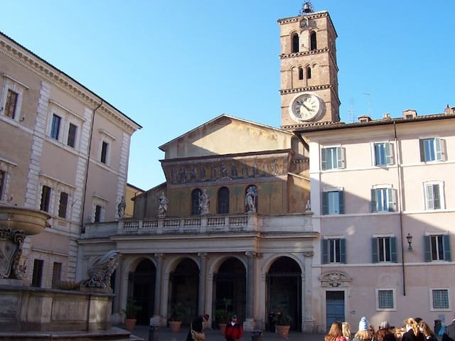
The basilica of Santa Maria in Trastevere is the most important place of Catholic worship in the Trastevere district of Rome, seat of the parish of the same name, and is located in the square of Santa Maria in Trastevere.
According to tradition, the basilica was founded by Pope Callisto I (217-222), in the place where oil gushed from the ground, and built by Julius I (337-352).
During the 8th and 9th centuries, the side aisles were added, the presbytery was rearranged and the confession was excavated, in which the remains of some martyrs were placed, including those of San Callisto, founder of the basilica.
The current architectural structure dates back to the reconstruction carried out in 1138-1148, with partly bare material coming from the Baths of Caracalla, and commissioned by Pope Innocent II (1130-1143). The pontiff was unable to see the completion and decoration of the basilica, but nevertheless left the necessary financial means to complete the work.
In the 16th century, the Austrian cardinal Marco Sittico Altemps had the Chapel of the Madonna della Clemenza built and some of the side ones designed by Martino Longhi the Elder.
In 1702, Pope Clement XI had the portico rebuilt and the façade modified to a design by Carlo Fontana.
During the pontificate of Pius IX, between 1866 and 1877, the church underwent a detailed restoration by the architect Virginio Vespignani.
384 paikallista suosittelee
Neitsyt Marian basilika Trasteveressä
Piazza di Santa Maria in TrastevereThe basilica of Santa Maria in Trastevere is the most important place of Catholic worship in the Trastevere district of Rome, seat of the parish of the same name, and is located in the square of Santa Maria in Trastevere.
According to tradition, the basilica was founded by Pope Callisto I (217-222), in the place where oil gushed from the ground, and built by Julius I (337-352).
During the 8th and 9th centuries, the side aisles were added, the presbytery was rearranged and the confession was excavated, in which the remains of some martyrs were placed, including those of San Callisto, founder of the basilica.
The current architectural structure dates back to the reconstruction carried out in 1138-1148, with partly bare material coming from the Baths of Caracalla, and commissioned by Pope Innocent II (1130-1143). The pontiff was unable to see the completion and decoration of the basilica, but nevertheless left the necessary financial means to complete the work.
In the 16th century, the Austrian cardinal Marco Sittico Altemps had the Chapel of the Madonna della Clemenza built and some of the side ones designed by Martino Longhi the Elder.
In 1702, Pope Clement XI had the portico rebuilt and the façade modified to a design by Carlo Fontana.
During the pontificate of Pius IX, between 1866 and 1877, the church underwent a detailed restoration by the architect Virginio Vespignani.
The Sistine Chapel (in Latin: Sacellum Sixtinum), dedicated to Maria Assunta in Cielo, is the main chapel of the apostolic palace, as well as one of the most famous cultural and artistic treasures of the Vatican City, included in the itinerary of the Vatican Museums. It was built between 1475 and 1481 approximately, at the time of Pope Sixtus IV della Rovere, from whom it took its name.
It is known all over the world both for being the place where the conclave and other official ceremonies of the pope are held (in the past also some papal coronations), and for being decorated with works of art among the best known and celebrated of artistic civilization. world, among which stand out the famous frescoes by Michelangelo, which cover the vault (1508-1512) and the back wall (of the Last Judgment) above the altar (about 1535-1541).
It is considered perhaps the most complete and important of that "visual theology, which has been called Biblia pauperum". The walls are decorated with a series of frescoes by some of the greatest Italian artists of the second half of the fifteenth century (Sandro Botticelli, Pietro Perugino, Pinturicchio, Domenico Ghirlandaio, Luca Signorelli, Piero di Cosimo, Cosimo Rosselli and others).
294 paikallista suosittelee
Sixtiniläinen kappeli
The Sistine Chapel (in Latin: Sacellum Sixtinum), dedicated to Maria Assunta in Cielo, is the main chapel of the apostolic palace, as well as one of the most famous cultural and artistic treasures of the Vatican City, included in the itinerary of the Vatican Museums. It was built between 1475 and 1481 approximately, at the time of Pope Sixtus IV della Rovere, from whom it took its name.
It is known all over the world both for being the place where the conclave and other official ceremonies of the pope are held (in the past also some papal coronations), and for being decorated with works of art among the best known and celebrated of artistic civilization. world, among which stand out the famous frescoes by Michelangelo, which cover the vault (1508-1512) and the back wall (of the Last Judgment) above the altar (about 1535-1541).
It is considered perhaps the most complete and important of that "visual theology, which has been called Biblia pauperum". The walls are decorated with a series of frescoes by some of the greatest Italian artists of the second half of the fifteenth century (Sandro Botticelli, Pietro Perugino, Pinturicchio, Domenico Ghirlandaio, Luca Signorelli, Piero di Cosimo, Cosimo Rosselli and others).
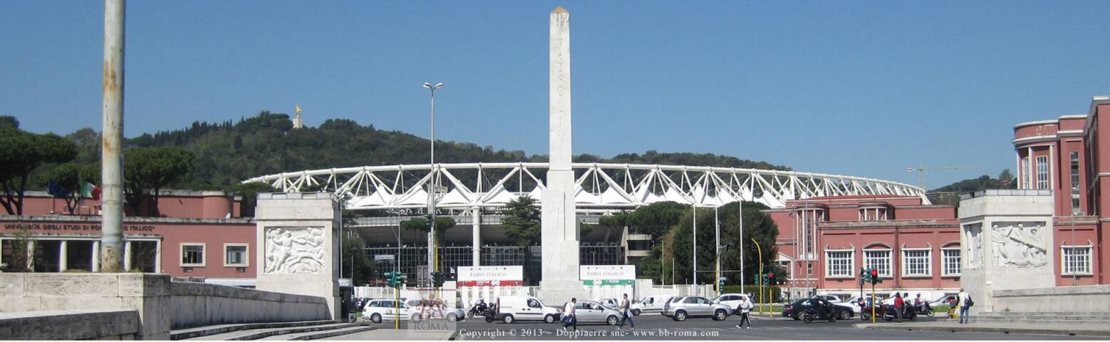
The Foro Italico (inaugurated in 1932 with the name of Foro Mussolini) is a vast sports complex located at the base of Monte Mario in Rome, conceived and built by Enrico Del Debbio between 1927 and 1933 and completed after the war between 1956 and 1968.
The sports complex of the Foro Italico, initially called "Foro Mussolini", was designed in 1927 by the architect Enrico Del Debbio. The initiator of the Forum was Renato Ricci, undersecretary for National Education and founder of the National Opera Balilla. For the choice of the place where to build it, three areas were initially considered: the Tiburtino district, in the area where the University City would later rise (1935), the Casal Palocco district and the Parioli district, where in the 1950s the Olympic village would be built for the 17th Olympics Games in 1960; all three hypotheses, however, were discarded and an area adjacent to the Tiber river was finally chosen, which through reclamation passed from a quagmire to a building area. The overhanging hill of Monte Mario, which guaranteed the sports complex a natural green background, was also bound by the Superintendence of Fine Arts.
The first works of the architectural complex were inaugurated on November 4, 1932: Palazzo H, seat of the Fascist Male Academy of Physical Education, the Stele Mussolini, the Stadio dei Marmi and the Stadio dei Cipressi (later the Hundred Thousand Stadium and today's Olympic Stadium).
In 1936 and later until 1941 Luigi Moretti, former author of the Fencing Academy, elaborated, without ever realizing them, expansive projects of the Forum towards Tor di Quinto, inserting Del Debbio's urban plan already completed.
79 paikallista suosittelee
Foro Italico
The Foro Italico (inaugurated in 1932 with the name of Foro Mussolini) is a vast sports complex located at the base of Monte Mario in Rome, conceived and built by Enrico Del Debbio between 1927 and 1933 and completed after the war between 1956 and 1968.
The sports complex of the Foro Italico, initially called "Foro Mussolini", was designed in 1927 by the architect Enrico Del Debbio. The initiator of the Forum was Renato Ricci, undersecretary for National Education and founder of the National Opera Balilla. For the choice of the place where to build it, three areas were initially considered: the Tiburtino district, in the area where the University City would later rise (1935), the Casal Palocco district and the Parioli district, where in the 1950s the Olympic village would be built for the 17th Olympics Games in 1960; all three hypotheses, however, were discarded and an area adjacent to the Tiber river was finally chosen, which through reclamation passed from a quagmire to a building area. The overhanging hill of Monte Mario, which guaranteed the sports complex a natural green background, was also bound by the Superintendence of Fine Arts.
The first works of the architectural complex were inaugurated on November 4, 1932: Palazzo H, seat of the Fascist Male Academy of Physical Education, the Stele Mussolini, the Stadio dei Marmi and the Stadio dei Cipressi (later the Hundred Thousand Stadium and today's Olympic Stadium).
In 1936 and later until 1941 Luigi Moretti, former author of the Fencing Academy, elaborated, without ever realizing them, expansive projects of the Forum towards Tor di Quinto, inserting Del Debbio's urban plan already completed.
The National Gallery of Modern and Contemporary Art is an Italian state museum based in Rome.
It houses the most complete collection dedicated to Italian and foreign art from the 19th century to today. Among paintings, drawings, sculptures and installations, the almost 20,000 works in the collection are an expression of the main artistic currents of the last two centuries, from neoclassicism to impressionism, from divisionism to the historical avant-gardes of the early twentieth century, from futurism and surrealism, at most conspicuous nucleus of works of Italian art between the 1920s and 1940s, from the twentieth century movement to the so-called Roman school, to reach the last fifty years of the last century.
264 paikallista suosittelee
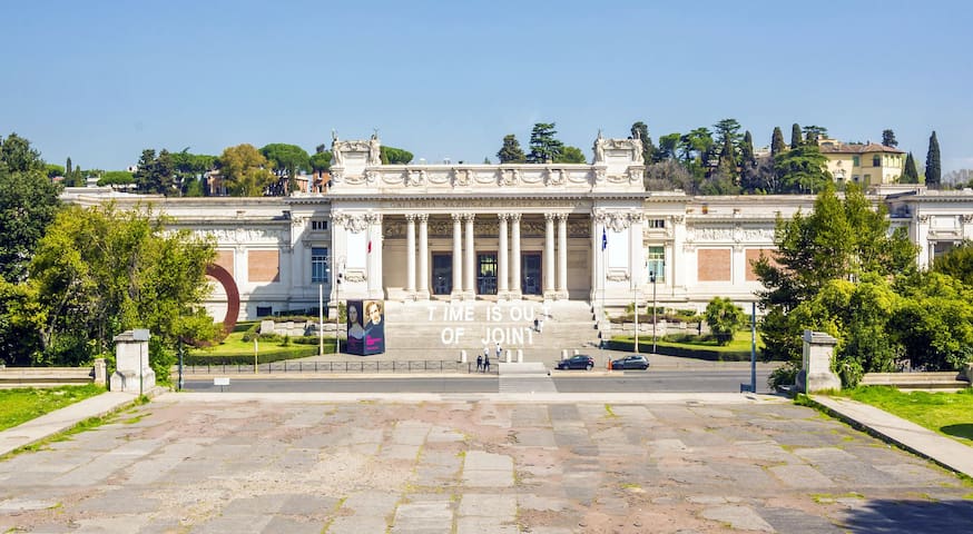
Kansallinen nykytaiteen ja nykytaiteen galleria
131 Viale delle Belle ArtiThe National Gallery of Modern and Contemporary Art is an Italian state museum based in Rome.
It houses the most complete collection dedicated to Italian and foreign art from the 19th century to today. Among paintings, drawings, sculptures and installations, the almost 20,000 works in the collection are an expression of the main artistic currents of the last two centuries, from neoclassicism to impressionism, from divisionism to the historical avant-gardes of the early twentieth century, from futurism and surrealism, at most conspicuous nucleus of works of Italian art between the 1920s and 1940s, from the twentieth century movement to the so-called Roman school, to reach the last fifty years of the last century.
l MAXXI - National Museum of XXI Century Arts is a museum based in Rome.
Designed by architect Zaha Hadid and managed by the homonymous foundation of the Ministry for Cultural Heritage and Activities, it is divided into two sections: MAXXI art and MAXXI architecture.
The MAXXI headquarters is located in the Flaminio district of Rome and is built in the area of the former Montello barracks next to the basilica of Santa Croce in Via Flaminia. The complex is located between via Masaccio and via Guido Reni, on the latter the main entrance. Of the former barracks, the body survives along the basilica of Santa Croce, and the facade on via Guido Reni, integrated in the Zaha Hadid project.
401 paikallista suosittelee
MAXXI - 21. vuosisadan kansallinen taidemuseo
4a Via Guido Renil MAXXI - National Museum of XXI Century Arts is a museum based in Rome.
Designed by architect Zaha Hadid and managed by the homonymous foundation of the Ministry for Cultural Heritage and Activities, it is divided into two sections: MAXXI art and MAXXI architecture.
The MAXXI headquarters is located in the Flaminio district of Rome and is built in the area of the former Montello barracks next to the basilica of Santa Croce in Via Flaminia. The complex is located between via Masaccio and via Guido Reni, on the latter the main entrance. Of the former barracks, the body survives along the basilica of Santa Croce, and the facade on via Guido Reni, integrated in the Zaha Hadid project.
The Ponte della Musica-Armando Trovajoli is a bridge in Rome that crosses the Tiber between the districts of Della Vittoria and Flaminio; suspended between Lungotevere Flaminio and Cadorna, the bridge connects the Parco della Musica auditorium, the park of Villa Glori, the MAXXI museum and the Olympic theater with the Foro Italico sports complex, the youth hostel, the green space of Monte Mario, the Museum of the Genius and the RAI auditorium.
Made of steel and reinforced concrete, it is reserved for bicycle and pedestrian use, as well as for public transport; [3] inaugurated in May 2011 as a bridge of Music, [4] two years later it was dedicated to the memory of Armando Trovajoli , assuming the current name.
Although the construction of such a work was already foreseen in the capital plan of 1929, it is only after seventy years that the project process is started.
Construction, which began in 2008, ended three years later.
Following the death of the Roman composer Armando Trovajoli in February 2013, on May 30 of the same year his name was added to the previous one of the bridge, which thus took on its current name.
6 paikallista suosittelee
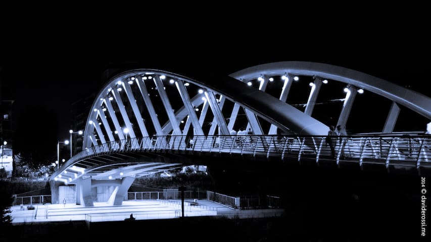
Musikkisilta
Ponte della Musica Armando TrovajoliThe Ponte della Musica-Armando Trovajoli is a bridge in Rome that crosses the Tiber between the districts of Della Vittoria and Flaminio; suspended between Lungotevere Flaminio and Cadorna, the bridge connects the Parco della Musica auditorium, the park of Villa Glori, the MAXXI museum and the Olympic theater with the Foro Italico sports complex, the youth hostel, the green space of Monte Mario, the Museum of the Genius and the RAI auditorium.
Made of steel and reinforced concrete, it is reserved for bicycle and pedestrian use, as well as for public transport; [3] inaugurated in May 2011 as a bridge of Music, [4] two years later it was dedicated to the memory of Armando Trovajoli , assuming the current name.
Although the construction of such a work was already foreseen in the capital plan of 1929, it is only after seventy years that the project process is started.
Construction, which began in 2008, ended three years later.
Following the death of the Roman composer Armando Trovajoli in February 2013, on May 30 of the same year his name was added to the previous one of the bridge, which thus took on its current name.
The Borghese gallery is an Italian state museum, located in the Villa Borghese Pinciana in Rome. It still houses a large part of the art collection begun by Scipione Borghese, cardinal-nephew of Paul V, who was also responsible for the construction of the villa itself.
There are exhibited works by Gian Lorenzo Bernini, Agnolo Bronzino, Antonio Canova, Caravaggio, Raphael, Perugino, Lorenzo Lotto, Antonello da Messina, Cranach, Annibale Carracci, Pieter Paul Rubens, Bellini, Tiziano. It can be considered unique in the world as regards the number and importance of Bernini's sculptures and Caravaggio's canvases.
In 1891 all the paintings preserved in the twelve rooms of the picture gallery of Palazzo Borghese in Via Ripetta were brought to the noble floor of the Villa Borghese Pinciana.
In 1902 it was transformed into a museum, following the acquisition by the Italian State of the collections belonging to the Fidecommisso Borghese.
The 1902 acquisition by the Italian State of the Villa Borghese has been called the deal of the century.
Closed in 1983, the gallery underwent a complete restoration that lasted fourteen years, restoring the original appearance of the exterior of the building with the plaster, the statues and the staircase with two flights.
The gallery reopened in June 1997.
681 paikallista suosittelee
Galleria Borghese ja museo
5 Piazzale Scipione BorgheseThe Borghese gallery is an Italian state museum, located in the Villa Borghese Pinciana in Rome. It still houses a large part of the art collection begun by Scipione Borghese, cardinal-nephew of Paul V, who was also responsible for the construction of the villa itself.
There are exhibited works by Gian Lorenzo Bernini, Agnolo Bronzino, Antonio Canova, Caravaggio, Raphael, Perugino, Lorenzo Lotto, Antonello da Messina, Cranach, Annibale Carracci, Pieter Paul Rubens, Bellini, Tiziano. It can be considered unique in the world as regards the number and importance of Bernini's sculptures and Caravaggio's canvases.
In 1891 all the paintings preserved in the twelve rooms of the picture gallery of Palazzo Borghese in Via Ripetta were brought to the noble floor of the Villa Borghese Pinciana.
In 1902 it was transformed into a museum, following the acquisition by the Italian State of the collections belonging to the Fidecommisso Borghese.
The 1902 acquisition by the Italian State of the Villa Borghese has been called the deal of the century.
Closed in 1983, the gallery underwent a complete restoration that lasted fourteen years, restoring the original appearance of the exterior of the building with the plaster, the statues and the staircase with two flights.
The gallery reopened in June 1997.
Villa Borghese is a large city park in the city of Rome that includes various types of green accommodation, from the Italian garden to the large English-style areas, buildings, small buildings, fountains and ponds.
It is the fifth largest public park in Rome (about 80 hectares).
The nucleus of the estate was already owned by the Borghese in 1580, on the site of which the position of the gardens of Lucullus (or horti luculliani) has also been identified.
The estate was expanded with a series of purchases and acquisitions by Cardinal Scipione Borghese, nephew of Pope Paul V and future patron of Gianlorenzo Bernini, with the aim of creating a "villa of delights" and the largest garden built in Rome by ' antiquity. In 1606 the construction of the buildings was entrusted by the cardinal to the architects Flaminio Ponzio and, after the death of his predecessor, to Giovanni Vasanzio (Jan van Santen); the architects were joined by the gardener Domenico Savini from Montelpulciano and by the intervention of other artists, such as Pietro and Gianlorenzo Bernini. The villa was completed in 1633.
In 1766, transformation works were undertaken by Prince Marcantonio IV Borghese (1730-1809), in the "Casino nobile" (now home to the Borghese Gallery) and in the "Casino dei giuochi acqua" (current "Aranciera" and home to the Carlo Museum. Bilotti), and above all in the park, with the arrangement of the "Garden of the lake", by the architects Antonio Asprucci and his son Mario. The whole garden was decorated with fountains and small factories that allowed you to enjoy suggestive perspective views.
At the beginning of the 19th century the villa was further enlarged by Camillo Borghese with the purchase of land towards Porta del Popolo and Porta Pinciana, which were integrated into the villa with the intervention of the architect Luigi Canina. Over the course of the century, much of the previous Italian garden was transformed into an English-style landscape garden. Throughout the century the gardens were open for festive strolls and popular festivals with songs and dances were hosted there.
The complex - the only case among the great patrician villas of the city, whose parks were all subjected to subdivision, and even the rarely saved villas - was purchased by the Italian state in 1901 and sold to the municipality of Rome in 1903 to be permanently open to the public. , just as the subdivision of the neighboring Villa Ludovisi was beginning on whose land the homonymous district was rising. The villa was purchased for 3 million lire at the time (equivalent to about 10 million euros today), and officially named "Villa comunale Umberto I formerly Borghese". The Romans never stopped calling it Villa Borghese.
2099 paikallista suosittelee
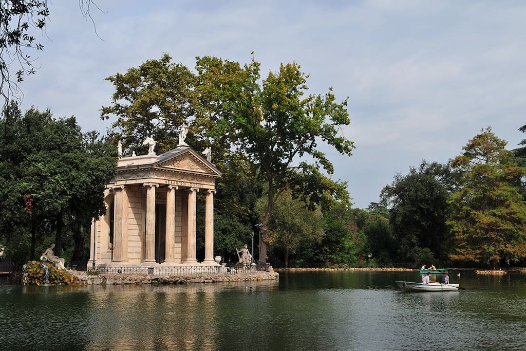
Villa Borghese
Piazzale Napoleone IVilla Borghese is a large city park in the city of Rome that includes various types of green accommodation, from the Italian garden to the large English-style areas, buildings, small buildings, fountains and ponds.
It is the fifth largest public park in Rome (about 80 hectares).
The nucleus of the estate was already owned by the Borghese in 1580, on the site of which the position of the gardens of Lucullus (or horti luculliani) has also been identified.
The estate was expanded with a series of purchases and acquisitions by Cardinal Scipione Borghese, nephew of Pope Paul V and future patron of Gianlorenzo Bernini, with the aim of creating a "villa of delights" and the largest garden built in Rome by ' antiquity. In 1606 the construction of the buildings was entrusted by the cardinal to the architects Flaminio Ponzio and, after the death of his predecessor, to Giovanni Vasanzio (Jan van Santen); the architects were joined by the gardener Domenico Savini from Montelpulciano and by the intervention of other artists, such as Pietro and Gianlorenzo Bernini. The villa was completed in 1633.
In 1766, transformation works were undertaken by Prince Marcantonio IV Borghese (1730-1809), in the "Casino nobile" (now home to the Borghese Gallery) and in the "Casino dei giuochi acqua" (current "Aranciera" and home to the Carlo Museum. Bilotti), and above all in the park, with the arrangement of the "Garden of the lake", by the architects Antonio Asprucci and his son Mario. The whole garden was decorated with fountains and small factories that allowed you to enjoy suggestive perspective views.
At the beginning of the 19th century the villa was further enlarged by Camillo Borghese with the purchase of land towards Porta del Popolo and Porta Pinciana, which were integrated into the villa with the intervention of the architect Luigi Canina. Over the course of the century, much of the previous Italian garden was transformed into an English-style landscape garden. Throughout the century the gardens were open for festive strolls and popular festivals with songs and dances were hosted there.
The complex - the only case among the great patrician villas of the city, whose parks were all subjected to subdivision, and even the rarely saved villas - was purchased by the Italian state in 1901 and sold to the municipality of Rome in 1903 to be permanently open to the public. , just as the subdivision of the neighboring Villa Ludovisi was beginning on whose land the homonymous district was rising. The villa was purchased for 3 million lire at the time (equivalent to about 10 million euros today), and officially named "Villa comunale Umberto I formerly Borghese". The Romans never stopped calling it Villa Borghese.
Via Vittorio Veneto, commonly called via Veneto, is a street in the historic center of Rome that leads uphill from Piazza Barberini to Porta Pinciana, in the Ludovisi district. In its initial section, it separates this district from that of Colonna.
Initially, like other streets in the district, it was dedicated to the Italian region of the same name. After the First World War, with resolution of the Municipal Council n. 37 of 25 October 1919, its name was changed in memory of the battle of Vittorio Veneto.
Designed at the end of the nineteenth century in place of Villa Ludovisi, it owes its fame above all to being at the center of the Dolce Vita period, thanks to the presence of numerous cafes (for example Harry's Bar) and hotels frequented by actors, singers and other celebrities, as well as journalists and photographers (or paparazzi). His fame was definitively sanctioned through Federico Fellini's film La dolce vita, which nevertheless rebuilt the road in the Cinecittà studios.
171 paikallista suosittelee
Via Veneto
Via Vittorio VenetoVia Vittorio Veneto, commonly called via Veneto, is a street in the historic center of Rome that leads uphill from Piazza Barberini to Porta Pinciana, in the Ludovisi district. In its initial section, it separates this district from that of Colonna.
Initially, like other streets in the district, it was dedicated to the Italian region of the same name. After the First World War, with resolution of the Municipal Council n. 37 of 25 October 1919, its name was changed in memory of the battle of Vittorio Veneto.
Designed at the end of the nineteenth century in place of Villa Ludovisi, it owes its fame above all to being at the center of the Dolce Vita period, thanks to the presence of numerous cafes (for example Harry's Bar) and hotels frequented by actors, singers and other celebrities, as well as journalists and photographers (or paparazzi). His fame was definitively sanctioned through Federico Fellini's film La dolce vita, which nevertheless rebuilt the road in the Cinecittà studios.
The church of Santa Maria della Concezione dei Cappuccini, or Our Lady of the Conception of the Capuchins, is a Catholic place of worship in Rome located at number 27 of via Veneto, built near Palazzo Barberini by Pope Urban VIII, in honor of his brother Antonio Barberini who was part of the Capuchin order, whose tomb is still preserved inside the church in front of the main altar. In this church there is also the tombstone of Cardinal Agapito Mosca (1678-1760), and the tomb of Father Mariano from Turin.
The main attraction of the church is certainly the crypt-ossuary decorated with the bones of about 4000 Capuchin friars, collected between 1528 and 1870 from the old cemetery of the Capuchin order, which was located in the church of Santa Croce and San Bonaventura dei Lucchesi near the Quirinale.
At the entrance to the crypt it is written on a plaque:
«What you are we were; what we are you will be. "
The crypt is made up of five small chapels connected by a corridor; inside there are also some whole bodies of some mummified friars wearing the typical clothes of the Capuchin friars and also a skeleton of a child on the ceiling holding a scales and a scythe.
The five rooms are characterized by the use of a part of the human skeleton in particular or a theme each (tibias, basins, skulls, 3 skeletons and resurrection). , butterflies, etc.).
The choice of decorating the crypt with bones, which could appear eerie and macabre, is actually a way of exorcising death and emphasizing that the body is nothing but a container for the soul, and as such once it is there 'has abandoned the container can be reused in another way.
16 paikallista suosittelee
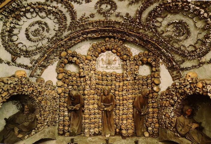
Convento dei Frati Cappuccini
27 Via Vittorio VenetoThe church of Santa Maria della Concezione dei Cappuccini, or Our Lady of the Conception of the Capuchins, is a Catholic place of worship in Rome located at number 27 of via Veneto, built near Palazzo Barberini by Pope Urban VIII, in honor of his brother Antonio Barberini who was part of the Capuchin order, whose tomb is still preserved inside the church in front of the main altar. In this church there is also the tombstone of Cardinal Agapito Mosca (1678-1760), and the tomb of Father Mariano from Turin.
The main attraction of the church is certainly the crypt-ossuary decorated with the bones of about 4000 Capuchin friars, collected between 1528 and 1870 from the old cemetery of the Capuchin order, which was located in the church of Santa Croce and San Bonaventura dei Lucchesi near the Quirinale.
At the entrance to the crypt it is written on a plaque:
«What you are we were; what we are you will be. "
The crypt is made up of five small chapels connected by a corridor; inside there are also some whole bodies of some mummified friars wearing the typical clothes of the Capuchin friars and also a skeleton of a child on the ceiling holding a scales and a scythe.
The five rooms are characterized by the use of a part of the human skeleton in particular or a theme each (tibias, basins, skulls, 3 skeletons and resurrection). , butterflies, etc.).
The choice of decorating the crypt with bones, which could appear eerie and macabre, is actually a way of exorcising death and emphasizing that the body is nothing but a container for the soul, and as such once it is there 'has abandoned the container can be reused in another way.
The Triton fountain is located in Rome in Piazza Barberini.
It is the work of Gian Lorenzo Bernini, to whom it was commissioned by Pope Urban VIII Barberini, as part of the overall refurbishment of the palace that the pontiff had built in 1625 and of the square it overlooked.
The Triton fountain, entirely sculpted in travertine, is made up of a low-height mixed-line basin located at ground level, above which are placed four open-mouthed dolphins that elegantly emerge from the water.
The latter, turning their tails and intertwining them, hold a large open bivalve shell, in the center of which the sea god Triton stands imposing.
The Triton, with a powerful and erect trunk and legs covered with scales, tilts his head back in the act of blowing into a large cone-shaped shell powerfully straight with his arms; unlike traditional tritons, usually depicted with monstrous connotations, the Berninian statue has a more human aspect.
In any case, a copious gush of water emerges from the buccina (or spiral shell) held by Triton which, dripping from the grooves of the shell, sprinkles and absorbs the whole work and finally collects in the pool below. Two papal coats of arms with the three bees, heraldic symbol of the Barberini family, are artistically intertwined between the tails of the dolphins.
16 paikallista suosittelee
Tritonin suihkulähde
Piazza BarberiniThe Triton fountain is located in Rome in Piazza Barberini.
It is the work of Gian Lorenzo Bernini, to whom it was commissioned by Pope Urban VIII Barberini, as part of the overall refurbishment of the palace that the pontiff had built in 1625 and of the square it overlooked.
The Triton fountain, entirely sculpted in travertine, is made up of a low-height mixed-line basin located at ground level, above which are placed four open-mouthed dolphins that elegantly emerge from the water.
The latter, turning their tails and intertwining them, hold a large open bivalve shell, in the center of which the sea god Triton stands imposing.
The Triton, with a powerful and erect trunk and legs covered with scales, tilts his head back in the act of blowing into a large cone-shaped shell powerfully straight with his arms; unlike traditional tritons, usually depicted with monstrous connotations, the Berninian statue has a more human aspect.
In any case, a copious gush of water emerges from the buccina (or spiral shell) held by Triton which, dripping from the grooves of the shell, sprinkles and absorbs the whole work and finally collects in the pool below. Two papal coats of arms with the three bees, heraldic symbol of the Barberini family, are artistically intertwined between the tails of the dolphins.
The papal archbasilica major Liberian archpriest of Santa Maria Maggiore, known simply by the name of basilica of Santa Maria Maggiore or Liberian basilica (because on its site it was thought there was a building of worship erected by Pope Liberius, which however has been denied by investigations carried out under the pavement), is one of the four papal basilicas of Rome, located in Piazza dell'Esquilino on the top of the homonymous hill, on the summit of the Cispio, between the Rione Monti and the Esquilino. It is the only basilica in Rome to have preserved the primitive early Christian structure, albeit enriched by subsequent additions.
Built, according to tradition, during the pontificate of Liberius (352-366), it was rebuilt or restructured by Pope Sixtus III (432-440), who dedicated it to the cult of the Madonna, whose divine motherhood had just been recognized by the council of Ephesus (431).
According to tradition, the Madonna appeared in a dream to Pope Liberius and the patrician John, suggesting that a basilica be erected in a place that would be miraculously indicated. So when on the morning of 5 August an unusual snowfall whitened the Esquiline, Liberio would have traced the perimeter of the new basilica in the snow, which was later built thanks to Giovanni's funding. The memory of this ancient building remains only in a passage from the Liber Pontificalis which states that Liberio «fecit basilicam nomini di lui iuxta Macellum Liviae».
In any case, on 5 August of each year, in memory of Our Lady of the Snow, the re-enactment of the so-called "miracle of the snow" takes place: during the celebration of mass in the morning and Vespers in the evening, it comes down from the center of the ceiling to caissons at the crypt of the manger, a cascade of white petals.
The previous church was dedicated to the belief in the Creed proclaimed by the First Council of Nicaea.
The basilica built by Sixtus III starting from the year 432 had three naves, divided by 21 bare columns on each side, surmounted by Ionic capitals, above which a continuous architrave ran. The central nave was lit by 21 windows on each side (half of which were subsequently plugged) and was surmounted by a wooden roof with exposed trusses.
424 paikallista suosittelee
Cappella Sistina di Santa Maria Maggiore
Piazza di Santa Maria MaggioreThe papal archbasilica major Liberian archpriest of Santa Maria Maggiore, known simply by the name of basilica of Santa Maria Maggiore or Liberian basilica (because on its site it was thought there was a building of worship erected by Pope Liberius, which however has been denied by investigations carried out under the pavement), is one of the four papal basilicas of Rome, located in Piazza dell'Esquilino on the top of the homonymous hill, on the summit of the Cispio, between the Rione Monti and the Esquilino. It is the only basilica in Rome to have preserved the primitive early Christian structure, albeit enriched by subsequent additions.
Built, according to tradition, during the pontificate of Liberius (352-366), it was rebuilt or restructured by Pope Sixtus III (432-440), who dedicated it to the cult of the Madonna, whose divine motherhood had just been recognized by the council of Ephesus (431).
According to tradition, the Madonna appeared in a dream to Pope Liberius and the patrician John, suggesting that a basilica be erected in a place that would be miraculously indicated. So when on the morning of 5 August an unusual snowfall whitened the Esquiline, Liberio would have traced the perimeter of the new basilica in the snow, which was later built thanks to Giovanni's funding. The memory of this ancient building remains only in a passage from the Liber Pontificalis which states that Liberio «fecit basilicam nomini di lui iuxta Macellum Liviae».
In any case, on 5 August of each year, in memory of Our Lady of the Snow, the re-enactment of the so-called "miracle of the snow" takes place: during the celebration of mass in the morning and Vespers in the evening, it comes down from the center of the ceiling to caissons at the crypt of the manger, a cascade of white petals.
The previous church was dedicated to the belief in the Creed proclaimed by the First Council of Nicaea.
The basilica built by Sixtus III starting from the year 432 had three naves, divided by 21 bare columns on each side, surmounted by Ionic capitals, above which a continuous architrave ran. The central nave was lit by 21 windows on each side (half of which were subsequently plugged) and was surmounted by a wooden roof with exposed trusses.
The Basilica of San Giovanni in Laterano, also defined as the Cathedral of Rome (full name Papal archbasilica major archpriest cathedral of the Most Holy Savior and of Saints John the Baptist and Evangelist in the Lateran; in Latin: Archibasilica Sanctissimi Salvatoris et Sanctorum Ioannis Baptistae et Ioannis Evangelistae in Laterano), is the mother church of the diocese of Rome, currently run by Pope Francis through the cardinal archpriest Angelo De Donatis. It is the first of the four major papal basilicas and the oldest and most important basilica in the West [8]. Located on the Celio hill, the basilica is the material representation of the Holy See, which has its residence here.
The basilica and the vast surrounding complex (including the Papal Palace of the Lateran, the Palazzo dei Canonici, the Pontifical Roman Major Seminary and the Pontifical Lateran University) enjoy the privileges of extraterritoriality recognized by the Italian Republic to the Holy See which therefore has full and exclusive jurisdiction.
The official name is "Papal Archbasilica of the Most Holy Savior and of Saints John the Baptist and the Evangelist in the Lateran". Pope Sylvester I, in the fourth century, dedicated it to the Most Holy Savior; then Pope Sergius III, in the ninth century, added the dedication to St. John the Baptist; finally Pope Lucio II, in the XII century, also included San Giovanni Evangelista.
It is called "archbasilica" because it is the most important of the four major papal basilicas; more precisely, she has the honorary title of Omnium Urbis et Orbis Ecclesiarum Mater et Caput, or Mother and Head of all the Churches of the City and of the World. It is finally called "in Laterano", or "Lateranense"; Lateranus was a cognomen of the gens Claudia, and in the area where the basilica was built there were some possessions (horti) of that family.
68 paikallista suosittelee
Basilica di San Giovanni in Laterano
4 Piazza di S. Giovanni in LateranoThe Basilica of San Giovanni in Laterano, also defined as the Cathedral of Rome (full name Papal archbasilica major archpriest cathedral of the Most Holy Savior and of Saints John the Baptist and Evangelist in the Lateran; in Latin: Archibasilica Sanctissimi Salvatoris et Sanctorum Ioannis Baptistae et Ioannis Evangelistae in Laterano), is the mother church of the diocese of Rome, currently run by Pope Francis through the cardinal archpriest Angelo De Donatis. It is the first of the four major papal basilicas and the oldest and most important basilica in the West [8]. Located on the Celio hill, the basilica is the material representation of the Holy See, which has its residence here.
The basilica and the vast surrounding complex (including the Papal Palace of the Lateran, the Palazzo dei Canonici, the Pontifical Roman Major Seminary and the Pontifical Lateran University) enjoy the privileges of extraterritoriality recognized by the Italian Republic to the Holy See which therefore has full and exclusive jurisdiction.
The official name is "Papal Archbasilica of the Most Holy Savior and of Saints John the Baptist and the Evangelist in the Lateran". Pope Sylvester I, in the fourth century, dedicated it to the Most Holy Savior; then Pope Sergius III, in the ninth century, added the dedication to St. John the Baptist; finally Pope Lucio II, in the XII century, also included San Giovanni Evangelista.
It is called "archbasilica" because it is the most important of the four major papal basilicas; more precisely, she has the honorary title of Omnium Urbis et Orbis Ecclesiarum Mater et Caput, or Mother and Head of all the Churches of the City and of the World. It is finally called "in Laterano", or "Lateranense"; Lateranus was a cognomen of the gens Claudia, and in the area where the basilica was built there were some possessions (horti) of that family.
The Scala Santa is, according to tradition, the staircase Jesus climbed to reach the hall where he underwent the interrogation of Pontius Pilate before the crucifixion.
The most famous and visited Holy Stairs, a pilgrimage destination for Catholics, is the one located in Rome, which is part of a complex called the "Pontifical Sanctuary of the Holy Stairs" in the immediate vicinity of the Basilica of San Giovanni in Laterano.
Holy Stairs of Rome
The legend, of medieval origin, states that it would be the same staircase climbed by Jesus, which was transported to Rome by Sant'Elena Imperatrice, mother of Constantine I, in 326.
Properly, the building called Scala Santa is a building complex built at the end of the sixteenth century by Pope Sixtus V as the new patriarchate of the bishop of Rome, replacing the previous one, demolished for the new construction. Built by Domenico Fontana in 1589, the building includes:
1) the Scala Santa proper, a set of 28 white marble steps covered with a wooden protection, flanked by four other flights of stairs, two to its right and the same number to its left;
2) the chapel of San Lorenzo in Palatio, called Sancta Sanctorum, that is, the private chapel of the pope, bishop of Rome, until the beginning of the fourteenth century; it is in this chapel that the Lateran Acheropita, that is the altarpiece of the papal chapel, is kept;
3) the oratory of San Silvestro in Palatio, which is accessed from the first flight of stairs on the right;
4) the oratory of the Santissimo Sacramento al Laterano and the Triclinium Leoninum flank the building.
117 paikallista suosittelee
Scala Santa
14 Piazza di S. Giovanni in LateranoThe Scala Santa is, according to tradition, the staircase Jesus climbed to reach the hall where he underwent the interrogation of Pontius Pilate before the crucifixion.
The most famous and visited Holy Stairs, a pilgrimage destination for Catholics, is the one located in Rome, which is part of a complex called the "Pontifical Sanctuary of the Holy Stairs" in the immediate vicinity of the Basilica of San Giovanni in Laterano.
Holy Stairs of Rome
The legend, of medieval origin, states that it would be the same staircase climbed by Jesus, which was transported to Rome by Sant'Elena Imperatrice, mother of Constantine I, in 326.
Properly, the building called Scala Santa is a building complex built at the end of the sixteenth century by Pope Sixtus V as the new patriarchate of the bishop of Rome, replacing the previous one, demolished for the new construction. Built by Domenico Fontana in 1589, the building includes:
1) the Scala Santa proper, a set of 28 white marble steps covered with a wooden protection, flanked by four other flights of stairs, two to its right and the same number to its left;
2) the chapel of San Lorenzo in Palatio, called Sancta Sanctorum, that is, the private chapel of the pope, bishop of Rome, until the beginning of the fourteenth century; it is in this chapel that the Lateran Acheropita, that is the altarpiece of the papal chapel, is kept;
3) the oratory of San Silvestro in Palatio, which is accessed from the first flight of stairs on the right;
4) the oratory of the Santissimo Sacramento al Laterano and the Triclinium Leoninum flank the building.
The Via Appia was a Roman road that connected Rome to Brundisium (Brindisi), one of the most important ports in ancient Italy, from which the trade routes to Greece and the East originated. Considered by the Romans the regina viarum (queen of the streets), it is universally considered, in consideration of the time in which it was built (late 4th century BC - 3rd century BC), one of the greatest civil engineering works of the ancient world for the enormous economic, military and cultural impact it had on Roman society.
Large stretches of the road, particularly in the suburbs of the city of Rome, are still preserved and practicable as well as a destination for archaeological tourism.
183 paikallista suosittelee
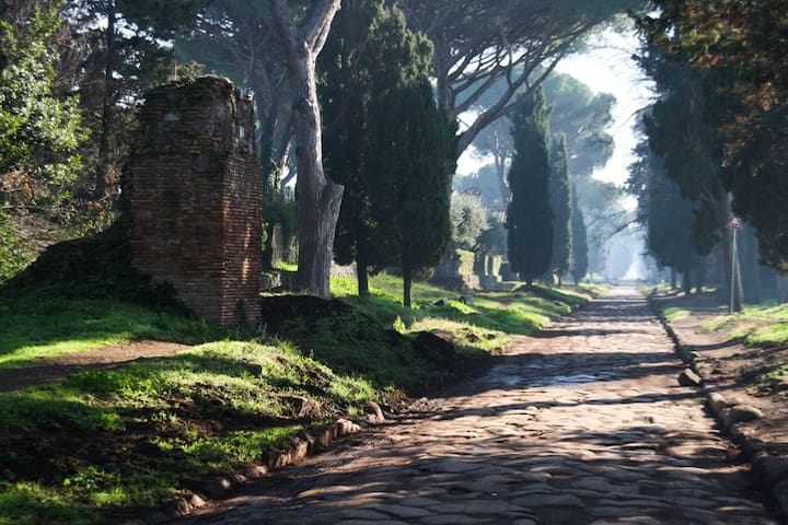
Via Appia Antica
Via Appia AnticaThe Via Appia was a Roman road that connected Rome to Brundisium (Brindisi), one of the most important ports in ancient Italy, from which the trade routes to Greece and the East originated. Considered by the Romans the regina viarum (queen of the streets), it is universally considered, in consideration of the time in which it was built (late 4th century BC - 3rd century BC), one of the greatest civil engineering works of the ancient world for the enormous economic, military and cultural impact it had on Roman society.
Large stretches of the road, particularly in the suburbs of the city of Rome, are still preserved and practicable as well as a destination for archaeological tourism.
The Supreme Court of Cassation, in the judicial system in force in the Italian Republic, represents the judge of legitimacy of last resort of the sentences issued by the ordinary judiciary. It carries out the functions of the Court of Cassation and the Supreme Court.
Its jurisdiction is not limited to a particular judicial district but extends to the whole national territory.
The first of the Italian pre-unification states to establish a court of cassation was the Kingdom of the two Sicilies in 1809. Subsequently, in the Kingdom of Sardinia, with the Albertine Statute, the Court of Cassation of Turin was established in 1848. With the birth in 1861 of the Kingdom of Italy, new so-called "regional" courts of cassation were established, heirs of the pre-unification states: Turin for the territories of the former Kingdom of Sardinia and the Lombard-Veneto Kingdom, Florence for the Grand Duchy and the Duchies , Rome for the territories that belonged to the Papal State, Naples and Palermo for the former Kingdom of the Two Sicilies.
On 24 March 1923, in the context of the centralizing policy of the fascist regime, the five courts were unified into one, based in Rome, with the official name of the Supreme Court of Cassation.
Because of the particular type of toga used for more formal occasions such as the inauguration of the judicial year, made up for the first president, the first deputy president and for the section presidents from a red velvet toga with an ermine fur border , touch (velvet hat), batiste cloth collar and white gloves, judges of the cassation are often referred to as "stoats".
It performs a nomophilactic function, which consists in ensuring the exact observance and uniform interpretation of the rules of law. In this sense, its judgments constitute a guiding criterion of national jurisprudence, which in taking its decisions can take into account the judgments issued by the Court. To this end, an office known as the Office of the Massimario is hinged at the Supreme Court, whose function is to identify the principles of law expressed by the Court in its rulings. However, when the Court of Cassation annuls a provision with postponement of the trial to the judge of the previous grade, the principle of law is binding for the judge to whom the judgment is referred.
20 paikallista suosittelee
Korkein oikeus rikosasioissa
Piazza CavourThe Supreme Court of Cassation, in the judicial system in force in the Italian Republic, represents the judge of legitimacy of last resort of the sentences issued by the ordinary judiciary. It carries out the functions of the Court of Cassation and the Supreme Court.
Its jurisdiction is not limited to a particular judicial district but extends to the whole national territory.
The first of the Italian pre-unification states to establish a court of cassation was the Kingdom of the two Sicilies in 1809. Subsequently, in the Kingdom of Sardinia, with the Albertine Statute, the Court of Cassation of Turin was established in 1848. With the birth in 1861 of the Kingdom of Italy, new so-called "regional" courts of cassation were established, heirs of the pre-unification states: Turin for the territories of the former Kingdom of Sardinia and the Lombard-Veneto Kingdom, Florence for the Grand Duchy and the Duchies , Rome for the territories that belonged to the Papal State, Naples and Palermo for the former Kingdom of the Two Sicilies.
On 24 March 1923, in the context of the centralizing policy of the fascist regime, the five courts were unified into one, based in Rome, with the official name of the Supreme Court of Cassation.
Because of the particular type of toga used for more formal occasions such as the inauguration of the judicial year, made up for the first president, the first deputy president and for the section presidents from a red velvet toga with an ermine fur border , touch (velvet hat), batiste cloth collar and white gloves, judges of the cassation are often referred to as "stoats".
It performs a nomophilactic function, which consists in ensuring the exact observance and uniform interpretation of the rules of law. In this sense, its judgments constitute a guiding criterion of national jurisprudence, which in taking its decisions can take into account the judgments issued by the Court. To this end, an office known as the Office of the Massimario is hinged at the Supreme Court, whose function is to identify the principles of law expressed by the Court in its rulings. However, when the Court of Cassation annuls a provision with postponement of the trial to the judge of the previous grade, the principle of law is binding for the judge to whom the judgment is referred.
The papal basilica of St. Paul Outside the Walls is one of the four papal basilicas of Rome, the second largest after that of St. Peter in the Vatican.
It rises along the Via Ostiense, in the district of the same name, near the left bank of the Tiber, about 2 km outside the Aurelian walls (hence its name), exiting the Porta San Paolo. It stands on the place that tradition indicates as that of the burial of the apostle Paul (about 3 km from the place, called "Tre Fontane", where he suffered martyrdom and was beheaded); the saint's tomb is located under the papal altar. For this reason, over the centuries, it has always been a destination for pilgrimages; since 1300, the date of the first Holy Year, it is part of the Jubilee itinerary to obtain the indulgence and the rite of opening the Holy Door is celebrated there. Since the eighth century, the care of the liturgy and the votive lamp on the tomb of the apostle has been entrusted to the Benedictine monks of the annexed abbey of San Paolo fuori le mura.
The entire complex of buildings enjoys the benefit of the extra-territoriality of the Holy See, despite being in the territory of the Italian Republic. The Basilica is an institution connected to the Holy See, including the adjoining abbey. The Holy See enjoys full and exclusive jurisdiction over the entire extraterritorial complex as well as the prohibition, by the Italian State, of carrying out expropriations or imposing taxes.
The place has been on the UNESCO World Heritage List since 1980.
The entire basilica, 131 m long, 65 wide, 29.70 high is the second largest of the four patriarchal basilicas of Rome.
217 paikallista suosittelee
Pyhän Paavalin basilika
1a Piazzale San PaoloThe papal basilica of St. Paul Outside the Walls is one of the four papal basilicas of Rome, the second largest after that of St. Peter in the Vatican.
It rises along the Via Ostiense, in the district of the same name, near the left bank of the Tiber, about 2 km outside the Aurelian walls (hence its name), exiting the Porta San Paolo. It stands on the place that tradition indicates as that of the burial of the apostle Paul (about 3 km from the place, called "Tre Fontane", where he suffered martyrdom and was beheaded); the saint's tomb is located under the papal altar. For this reason, over the centuries, it has always been a destination for pilgrimages; since 1300, the date of the first Holy Year, it is part of the Jubilee itinerary to obtain the indulgence and the rite of opening the Holy Door is celebrated there. Since the eighth century, the care of the liturgy and the votive lamp on the tomb of the apostle has been entrusted to the Benedictine monks of the annexed abbey of San Paolo fuori le mura.
The entire complex of buildings enjoys the benefit of the extra-territoriality of the Holy See, despite being in the territory of the Italian Republic. The Basilica is an institution connected to the Holy See, including the adjoining abbey. The Holy See enjoys full and exclusive jurisdiction over the entire extraterritorial complex as well as the prohibition, by the Italian State, of carrying out expropriations or imposing taxes.
The place has been on the UNESCO World Heritage List since 1980.
The entire basilica, 131 m long, 65 wide, 29.70 high is the second largest of the four patriarchal basilicas of Rome.
Offerta gastronomica
Antico Caffè Greco
86 Via dei CondottiVia dei Condotti, 86, Roma
Zuma Rome
48 Via della Fontanella di Borghese Via della Fontanella di Borghese, 48, Roma
- Via della Croce, 25/26 Roma (Piazza di Spagna)
- Via degli Orfani, 87 Roma (Pantheon)
- Via del Corso, 335 Roma (Via del Corso)
29 paikallista suosittelee
Venchi Cioccolato e Gelato, Roma Fontana di Trevi
335 Via del Corso- Via della Croce, 25/26 Roma (Piazza di Spagna)
- Via degli Orfani, 87 Roma (Pantheon)
- Via del Corso, 335 Roma (Via del Corso)
La Casa del Caffè Tazza d'Oro
84 Via degli OrfaniVia degli Orfani, 84, Roma
Giolitti
40 Via degli Uffici del VicarioVia degli Uffici del Vicario, 40, Roma
Gelateria Della Palma
19-23 Via della MaddalenaVia della Maddalena, 19-23, Roma
Antica Hostaria Romanesca
40 Piazza Campo de' FioriPiazza Campo de' Fiori, 40, Roma
Pizzeria Da Baffetto
114 Via del Governo VecchioVia del Governo Vecchio, 114, Roma
La Montecarlo
13 Vicolo Savelli Vicolo Savelli, 13, Roma
Dar Filettaro a Santa Barbara
88 Largo dei LibrariLargo dei Librari, 88, Roma
Trattoria Otello Trastevere
47/53 Via della Pelliccia Via della Pelliccia, 47/53, Roma
Tonnarello
1/2/3 Via della PagliaVia della Paglia, 1/2/3, Roma
Sora Margherita
30 Piazza delle Cinque ScolePiazza delle Cinque Scole, 30, Roma
Osteria dei Pontefici
53 Via Gregorio VIIVia Gregorio VII, 53, Roma
La Zanzara
84 Via CrescenzioVia Crescenzio, 84, Roma
Le Guide ai Quartieri
Trastevere is the thirteenth district of Rome, indicated with R. XIII, as well as the largest. The name derives from the Latin trans Tiberim ('beyond the Tiber'), which was already the ancient name of the corresponding Augustan region, because the city had its origin and main development on the opposite bank. It is located on the right bank of the Tiber and south of the Vatican City, and includes the plain on the bend of the river and the Janiculum hill. It is bordered to the south and west by the Gianicolo Walls, to the north by the Galleria Principe di Savoia-Aosta, to the east by the Tiber River.
In 1744 Pope Benedict XIV made a revision of the delimitation of the districts, giving Trastevere its current boundaries.
After 1870 the walls were built to block the flooding of the Tiber: this certainly brought greater security at the price of the destruction of all the most characteristic places that were on the shore.
Alberto Sordi was born in the district, in a demolished house mentioned in a commemorative plaque in via San Cosimato.
Today Trastevere still maintains its character thanks to the winding streets covered with cobblestones overlooked by medieval public houses. The night is filled with people, both Italian and foreign, thanks to the wealth of typical Roman restaurants, clubs and pubs for every price range.
Another feature that characterizes the area are the monuments to Gioachino Belli and the Roman poet Trilussa.
1330 paikallista suosittelee

Trastevere
Trastevere is the thirteenth district of Rome, indicated with R. XIII, as well as the largest. The name derives from the Latin trans Tiberim ('beyond the Tiber'), which was already the ancient name of the corresponding Augustan region, because the city had its origin and main development on the opposite bank. It is located on the right bank of the Tiber and south of the Vatican City, and includes the plain on the bend of the river and the Janiculum hill. It is bordered to the south and west by the Gianicolo Walls, to the north by the Galleria Principe di Savoia-Aosta, to the east by the Tiber River.
In 1744 Pope Benedict XIV made a revision of the delimitation of the districts, giving Trastevere its current boundaries.
After 1870 the walls were built to block the flooding of the Tiber: this certainly brought greater security at the price of the destruction of all the most characteristic places that were on the shore.
Alberto Sordi was born in the district, in a demolished house mentioned in a commemorative plaque in via San Cosimato.
Today Trastevere still maintains its character thanks to the winding streets covered with cobblestones overlooked by medieval public houses. The night is filled with people, both Italian and foreign, thanks to the wealth of typical Roman restaurants, clubs and pubs for every price range.
Another feature that characterizes the area are the monuments to Gioachino Belli and the Roman poet Trilussa.
The name derives from the fact that the term monti in the Middle Ages meant the vast area, sparsely inhabited, which included three of the seven hills: the Esquiline, the Viminale, and part of the Quirinale. Today the Esquiline no longer belongs to him, but the name has remained.
In Roman times the area was densely populated: the upper part of the district (from the Baths of Diocletian to the Suburra) was made up of noble domus around the Vicus patricius (today via Urbana). The lower and marshy part, still drained by the Cloaca Maxima, developed around the via dell'argiletum (the name was due to the continuous presence of clay and mud coming from the simultaneous confluence of the rainwater of the Quirinale, Esquilino and Viminale hills) which it corresponded to the current via Leonina and via Madonna dei Monti. This area, called Suburra, was known to be plebeian, full of brothels and infamous inns [1]. Further down, in the valley between the Campidoglio and Palatine Hill, there were the Imperial Forums, separated from the popular neighborhood which was always at risk of fire by means of the large fire break wall in gabina stone which still today acts as an architectural backdrop to the Forum of Augustus.
Piazza San Francesco di Paola, Loggia Borgia and Arco della Suburra, in a photo from 1982
In the Middle Ages the situation was quite different: the Roman aqueducts had been damaged and it was difficult to get water due to the raised ground (it is a hilly area); for this reason the inhabitants tended to move to the Campo Marzio, a flat area downstream of the hills. After all, the inhabitants of Rome were used to drinking water from the Tiber, which was drinkable at the time.
From the Middle Ages until the early nineteenth century the district remained essentially an area rich in vineyards and vegetable gardens, sparsely populated due to the scarcity of water and the distance from the Vatican, the cultural center of that period. The only factor that ensured that the area did not become totally uninhabited was the presence of the basilicas of San Giovanni in Laterano and Santa Maria Maggiore, today connected by the historic Via Merulana: the continuous influx of pilgrims always guaranteed a large number of people on the territory.
After the urban arrangement in 1570 by Cardinal Michele Bonelli, known as the Alexandrino (nephew of Pope Pius V Ghisleri), of the area near the campo vaccino and via Alessandrina, subsequently, thanks to the new roads built by Pope Sixtus V ( the so-called Sistine route), the district was repopulated starting from the 1600s.
Subsequently, the urban development of the late 1800s (Rome had just become the capital) and the great demolitions of the Fascist period completely changed the face of the district. In particular, between 1924 and 1936 a large portion of the lower part of the district was destroyed to build via dei Fori Imperiali (then via dell'Impero) and bring to light the remains of the Imperial Forums. The building fury of the first forty years of the reign of Italy and the fascist demolitions have spared both the Suburra area, of which tourists love the "picturesque", as much as that of Trastevere.
Particularly appreciated from this point of view and increasingly popular, in recent years, is the area between via Nazionale and via Cavour which, due to the peculiarity of the houses, the narrow streets, the artisan shops, the small shops seems to preserve the characteristics of the Nineteenth-century Rome.
The area, full of trattorias, bars and various clubs, gravitates to the square of the Madonna dei Monti, near the church of the same name, which still serves as a meeting place for local residents and occasional visitors. Despite the increase in the price of buildings in the historic center, the district is still one of the most populous in Rome today.
Monti is a district in constant movement and an attraction for thousands of tourists, with its main arteries, the Colosseum, the Imperial Forums, its towers and noble palaces, which make it one of the most beautiful and full of history districts in the whole Rome.
399 paikallista suosittelee

Rione Monti
The name derives from the fact that the term monti in the Middle Ages meant the vast area, sparsely inhabited, which included three of the seven hills: the Esquiline, the Viminale, and part of the Quirinale. Today the Esquiline no longer belongs to him, but the name has remained.
In Roman times the area was densely populated: the upper part of the district (from the Baths of Diocletian to the Suburra) was made up of noble domus around the Vicus patricius (today via Urbana). The lower and marshy part, still drained by the Cloaca Maxima, developed around the via dell'argiletum (the name was due to the continuous presence of clay and mud coming from the simultaneous confluence of the rainwater of the Quirinale, Esquilino and Viminale hills) which it corresponded to the current via Leonina and via Madonna dei Monti. This area, called Suburra, was known to be plebeian, full of brothels and infamous inns [1]. Further down, in the valley between the Campidoglio and Palatine Hill, there were the Imperial Forums, separated from the popular neighborhood which was always at risk of fire by means of the large fire break wall in gabina stone which still today acts as an architectural backdrop to the Forum of Augustus.
Piazza San Francesco di Paola, Loggia Borgia and Arco della Suburra, in a photo from 1982
In the Middle Ages the situation was quite different: the Roman aqueducts had been damaged and it was difficult to get water due to the raised ground (it is a hilly area); for this reason the inhabitants tended to move to the Campo Marzio, a flat area downstream of the hills. After all, the inhabitants of Rome were used to drinking water from the Tiber, which was drinkable at the time.
From the Middle Ages until the early nineteenth century the district remained essentially an area rich in vineyards and vegetable gardens, sparsely populated due to the scarcity of water and the distance from the Vatican, the cultural center of that period. The only factor that ensured that the area did not become totally uninhabited was the presence of the basilicas of San Giovanni in Laterano and Santa Maria Maggiore, today connected by the historic Via Merulana: the continuous influx of pilgrims always guaranteed a large number of people on the territory.
After the urban arrangement in 1570 by Cardinal Michele Bonelli, known as the Alexandrino (nephew of Pope Pius V Ghisleri), of the area near the campo vaccino and via Alessandrina, subsequently, thanks to the new roads built by Pope Sixtus V ( the so-called Sistine route), the district was repopulated starting from the 1600s.
Subsequently, the urban development of the late 1800s (Rome had just become the capital) and the great demolitions of the Fascist period completely changed the face of the district. In particular, between 1924 and 1936 a large portion of the lower part of the district was destroyed to build via dei Fori Imperiali (then via dell'Impero) and bring to light the remains of the Imperial Forums. The building fury of the first forty years of the reign of Italy and the fascist demolitions have spared both the Suburra area, of which tourists love the "picturesque", as much as that of Trastevere.
Particularly appreciated from this point of view and increasingly popular, in recent years, is the area between via Nazionale and via Cavour which, due to the peculiarity of the houses, the narrow streets, the artisan shops, the small shops seems to preserve the characteristics of the Nineteenth-century Rome.
The area, full of trattorias, bars and various clubs, gravitates to the square of the Madonna dei Monti, near the church of the same name, which still serves as a meeting place for local residents and occasional visitors. Despite the increase in the price of buildings in the historic center, the district is still one of the most populous in Rome today.
Monti is a district in constant movement and an attraction for thousands of tourists, with its main arteries, the Colosseum, the Imperial Forums, its towers and noble palaces, which make it one of the most beautiful and full of history districts in the whole Rome.
The E.U.R. Universal Exposition Rome (formerly E42 Universal Exposition 1942) is an urban and architectural complex in Rome.
The area was designed in the thirties of the twentieth century for the construction of the seat of the Universal Exposition of Rome, from whose acronym it took its name, planned for 1942 but which never took place due to the beginning of the Second World War; the complex was completed in the following decades, modifying and expanding the original project. It houses some examples of monumental architecture, which coexist with modern buildings built in the following decades, with most of the buildings being owned by the state-owned company of the same name.
The toponym is also used to indicate the XXXII district of Rome and the urban area 12A.
In 1935 the governor of Rome, Bottai, proposed to Mussolini to nominate the capital for the future universal exhibition of 1942, which would have made it possible to celebrate the twentieth anniversary of the march on Rome and propose the success of fascism in front of an international audience. The government supported the initiative with the creation of a special autonomous body - the Autonomous Universal Exhibition of Rome - chaired by Senator Vittorio Cini [1]. The area of the Tre Fontane was chosen, preferred to ideally connect imperial Rome, represented by the Baths of Caracalla, with the Tyrrhenian Sea along the Via Imperiale (today via Cristoforo Colombo): the new district was designed to be the third pole of expansion in southwest of the city. This southern area of Rome was unrelated to the 1931 Master Plan, which required the adoption of certain regulations to allow the project to be carried out: a special commission approved the regulations through some detailed executive plans.
Senator Cini proposed the collaboration of numerous Italian architects - Giuseppe Pagano, Luigi Piccinato, Luigi Vietti, Adalberto Libera, Gaetano Minnucci, Ernesto Lapadula, Mario Romano, Luigi Moretti - under the technical coordination of Marcello Piacentini, already appreciated by the fascist regime for the his essentialized classicism [2]. The governorate had huge financial resources [3] for the expropriations of the approximately 400 hectares of extension of the project and the construction of the buildings; the main project was completed only in 1938. The works began on April 26, 1937, when Mussolini planted a Roman pine on the site where the new Roman quarter would be born.
The district was inspired, according to the ideology of fascism, by classical Roman urban planning, bringing to it the elements of Italian rationalism: the structure includes a varied system with orthogonal axes and majestic and imposing architectural buildings, massive and squared, mostly built with white marble and travertine to remind the temples and buildings of imperial Rome. The symbolic element of this architectural model is the Palazzo della Civiltà Italiana, nicknamed the "Square Colosseum". However, the universal exhibition never took place due to the delay of the construction works, the sudden death of the governor Piero Colonna and the preparations for the Italian participation in the Second World War: the original project was never completed and the works were completed. interrupted in 1942. Most of the works were destined to remain unfinished; others, such as the theater on the Imperial Square, were never started [4]. Despite this, the Exposition favored the execution of a complex of works and services which would subsequently favor the formation of a new neighborhood. The project was redefined and completed in the following decades with modern buildings, congress buildings and sports architecture.
In 1944 the territory of the EUR was occupied by the German armed forces that were advancing from the sea towards Rome and was used as a place of shelter for the troops; the Palazzo della Civiltà Italiana was transformed into a repair shop, while the workers' village was transformed into a barracks. The Germans had completely emptied the buildings, in particular they had taken away all the equipment from the restaurant to equip their military canteens; civilians emptied the workers' village. When the Germans began their retreat by abandoning Rome on 2 June 1944, they were replaced at the Eur by the allies; after which it remained empty and uninhabitable [5]. Of the E42 company after the war only ruins and undeveloped spaces not connected to the city remain, but it is precisely from here that the development of the Eur starts, which starting from the early 1950s represented the exemplary case of post-war reconstruction, which was at the base of the Italian socio-economic recovery. Green, a great lack of Rome, would have been the characteristic, the specialty of Eur. Therefore, a park-district, whose urban qualities needed to be enhanced.
71 paikallista suosittelee
EUR
The E.U.R. Universal Exposition Rome (formerly E42 Universal Exposition 1942) is an urban and architectural complex in Rome.
The area was designed in the thirties of the twentieth century for the construction of the seat of the Universal Exposition of Rome, from whose acronym it took its name, planned for 1942 but which never took place due to the beginning of the Second World War; the complex was completed in the following decades, modifying and expanding the original project. It houses some examples of monumental architecture, which coexist with modern buildings built in the following decades, with most of the buildings being owned by the state-owned company of the same name.
The toponym is also used to indicate the XXXII district of Rome and the urban area 12A.
In 1935 the governor of Rome, Bottai, proposed to Mussolini to nominate the capital for the future universal exhibition of 1942, which would have made it possible to celebrate the twentieth anniversary of the march on Rome and propose the success of fascism in front of an international audience. The government supported the initiative with the creation of a special autonomous body - the Autonomous Universal Exhibition of Rome - chaired by Senator Vittorio Cini [1]. The area of the Tre Fontane was chosen, preferred to ideally connect imperial Rome, represented by the Baths of Caracalla, with the Tyrrhenian Sea along the Via Imperiale (today via Cristoforo Colombo): the new district was designed to be the third pole of expansion in southwest of the city. This southern area of Rome was unrelated to the 1931 Master Plan, which required the adoption of certain regulations to allow the project to be carried out: a special commission approved the regulations through some detailed executive plans.
Senator Cini proposed the collaboration of numerous Italian architects - Giuseppe Pagano, Luigi Piccinato, Luigi Vietti, Adalberto Libera, Gaetano Minnucci, Ernesto Lapadula, Mario Romano, Luigi Moretti - under the technical coordination of Marcello Piacentini, already appreciated by the fascist regime for the his essentialized classicism [2]. The governorate had huge financial resources [3] for the expropriations of the approximately 400 hectares of extension of the project and the construction of the buildings; the main project was completed only in 1938. The works began on April 26, 1937, when Mussolini planted a Roman pine on the site where the new Roman quarter would be born.
The district was inspired, according to the ideology of fascism, by classical Roman urban planning, bringing to it the elements of Italian rationalism: the structure includes a varied system with orthogonal axes and majestic and imposing architectural buildings, massive and squared, mostly built with white marble and travertine to remind the temples and buildings of imperial Rome. The symbolic element of this architectural model is the Palazzo della Civiltà Italiana, nicknamed the "Square Colosseum". However, the universal exhibition never took place due to the delay of the construction works, the sudden death of the governor Piero Colonna and the preparations for the Italian participation in the Second World War: the original project was never completed and the works were completed. interrupted in 1942. Most of the works were destined to remain unfinished; others, such as the theater on the Imperial Square, were never started [4]. Despite this, the Exposition favored the execution of a complex of works and services which would subsequently favor the formation of a new neighborhood. The project was redefined and completed in the following decades with modern buildings, congress buildings and sports architecture.
In 1944 the territory of the EUR was occupied by the German armed forces that were advancing from the sea towards Rome and was used as a place of shelter for the troops; the Palazzo della Civiltà Italiana was transformed into a repair shop, while the workers' village was transformed into a barracks. The Germans had completely emptied the buildings, in particular they had taken away all the equipment from the restaurant to equip their military canteens; civilians emptied the workers' village. When the Germans began their retreat by abandoning Rome on 2 June 1944, they were replaced at the Eur by the allies; after which it remained empty and uninhabitable [5]. Of the E42 company after the war only ruins and undeveloped spaces not connected to the city remain, but it is precisely from here that the development of the Eur starts, which starting from the early 1950s represented the exemplary case of post-war reconstruction, which was at the base of the Italian socio-economic recovery. Green, a great lack of Rome, would have been the characteristic, the specialty of Eur. Therefore, a park-district, whose urban qualities needed to be enhanced.
Le vie dello Shopping
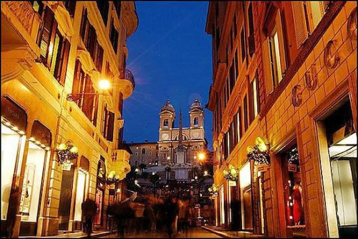
Via Condotti
Via dei Condotti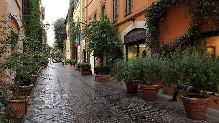
Via Margutta
Via Margutta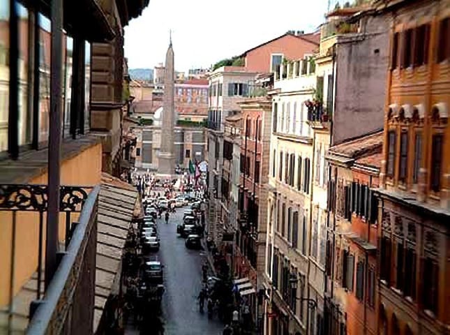
Via del Babuino
Via del Babuino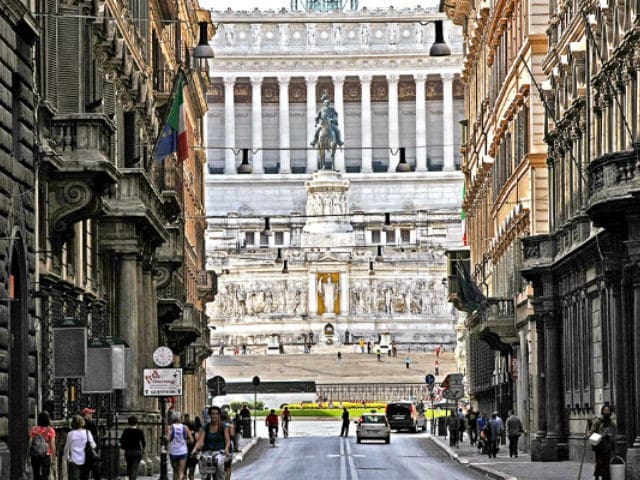
Via del Corso
Via del CorsoRinascente Roma Tritone
61 Via del Tritone
Via Cola di Rienzo
Via Cola di Rienzo
Via Tomacelli
Via TomacelliFuori "porta"/Fuori Roma
The ancient city of Ostia, founded in the fourth century BC, settled in the territory. as a military camp. It developed during the Roman imperial age as a port commercial center, linked to the supply of grain in the capital. Due to the inadequacy of the river port in 42 AD. Claudio began the construction of an artificial port to the north, connected to the Tiber by an artificial canal and equipped with a lighthouse; a second hexagonal port was built between 106 and 113 under Trajan, the remains were in the private property of the Sforza Cesarini Dukes. At the time of its maximum development Ostia reached 75,000 inhabitants, it declined with the crisis of the third century. It revived in the fourth century as a residential location, while commercial and administrative activities had moved to the city of Porto.
Already from the third century it was an episcopal seat. The aqueduct ceased to function at the end of the 5th century. In 537, during a siege of the Goths, it was defended by the Byzantine general Belisarius. The city, however, had fallen into decline and depopulated.
It remained the gateway to Rome from the Tiber, along which pilgrims, merchants and delegations arrived by sea went up. In the 9th century it was sacked by the Saracens. Pope Gregory IV then fortified the village built to give refuge to the workers of the salt mines along the Via Ostiense, which took the name of Gregoriopoli, and the ancient city was definitively abandoned.
At the end of the fifteenth century the bishop Giuliano della Rovere, who later became pope with the name of Julius II, had the castle that took his name built, completed the construction of the basilica of Sant'Aurea, begun shortly before by Cardinal Guillaume d'Estouteville on the site of the tomb of Santa Monica and near the tomb of Santa Aurea, and redo the walls. According to Vasari, the architect of this restructuring was Baccio Pontelli.
The structure maintained its defensive function until 1557, when an extraordinary flood diverted the course of the Tiber, leaving the moat around the wall dry as well. The castle, which had been the seat of customs and duties, lost its function and fell into disrepair: it was used as a stable and warehouse by farmers and shepherds of the area, now swamped, while the tower was used as a prison. In the nineteenth century the prisoners were used for the excavation of the Roman city.
The fortress and the village were restored in various stages during the twentieth century.
The archaeological area of Ostia Antica, between viale dei Romagnoli, via di Tor Boacciana and the Tiber river. Roman city of the 7th century BC
Here are preserved the remains of part of the ancient city, excavated during the nineteenth and especially the twentieth century. Together with the public monuments, numerous private buildings have been preserved (residential houses, production facilities, headquarters of associations), which allow you to relive everyday life as it was in antiquity.
216 paikallista suosittelee
Ostia Antica
The ancient city of Ostia, founded in the fourth century BC, settled in the territory. as a military camp. It developed during the Roman imperial age as a port commercial center, linked to the supply of grain in the capital. Due to the inadequacy of the river port in 42 AD. Claudio began the construction of an artificial port to the north, connected to the Tiber by an artificial canal and equipped with a lighthouse; a second hexagonal port was built between 106 and 113 under Trajan, the remains were in the private property of the Sforza Cesarini Dukes. At the time of its maximum development Ostia reached 75,000 inhabitants, it declined with the crisis of the third century. It revived in the fourth century as a residential location, while commercial and administrative activities had moved to the city of Porto.
Already from the third century it was an episcopal seat. The aqueduct ceased to function at the end of the 5th century. In 537, during a siege of the Goths, it was defended by the Byzantine general Belisarius. The city, however, had fallen into decline and depopulated.
It remained the gateway to Rome from the Tiber, along which pilgrims, merchants and delegations arrived by sea went up. In the 9th century it was sacked by the Saracens. Pope Gregory IV then fortified the village built to give refuge to the workers of the salt mines along the Via Ostiense, which took the name of Gregoriopoli, and the ancient city was definitively abandoned.
At the end of the fifteenth century the bishop Giuliano della Rovere, who later became pope with the name of Julius II, had the castle that took his name built, completed the construction of the basilica of Sant'Aurea, begun shortly before by Cardinal Guillaume d'Estouteville on the site of the tomb of Santa Monica and near the tomb of Santa Aurea, and redo the walls. According to Vasari, the architect of this restructuring was Baccio Pontelli.
The structure maintained its defensive function until 1557, when an extraordinary flood diverted the course of the Tiber, leaving the moat around the wall dry as well. The castle, which had been the seat of customs and duties, lost its function and fell into disrepair: it was used as a stable and warehouse by farmers and shepherds of the area, now swamped, while the tower was used as a prison. In the nineteenth century the prisoners were used for the excavation of the Roman city.
The fortress and the village were restored in various stages during the twentieth century.
The archaeological area of Ostia Antica, between viale dei Romagnoli, via di Tor Boacciana and the Tiber river. Roman city of the 7th century BC
Here are preserved the remains of part of the ancient city, excavated during the nineteenth and especially the twentieth century. Together with the public monuments, numerous private buildings have been preserved (residential houses, production facilities, headquarters of associations), which allow you to relive everyday life as it was in antiquity.
Villa Adriana was an extra-urban imperial residence, built near Tivoli by the emperor Hadrian (117-138).
The structure appears as a rich complex of buildings built gradually and extended over a large area, which must have covered about 120 hectares, in an area rich in water sources a few kilometers from the town of Tibur and 17 Roman miles from the Urbs. In 1999 Villa Adriana was declared a World Heritage Site by UNESCO.
It is located on the Tiburtini Mountains, about 28 km (17 Roman miles) from Rome, from which it was reachable both by means of the Via Tiburtina Valeria or the Via Prenestina, and by navigating the Aniene river. The Villa was located on the right of via Tiburtina, just beyond the Lucano bridge, extending almost to the slopes of Mount Ripoli on which Tivoli stands.
The chosen area extended between the valleys of the ditches of Risicoli or Roccabruna to the west and of the Acqua Ferrata to the east, which, once gathered, then flow into the Aniene; it was an area rich in water and four of the ancient Roman aqueducts that served Rome passed through it (Anio Vetus, Anio Novus, Aqua Marcia and Aqua Claudia). Nearby there is still the sulfur spring of Acque Albule (Bagni di Tivoli), which was known and appreciated by the emperor. In the surrounding area there were also numerous quarries for building materials (travertine, tuff and limestone for making lime).
164 paikallista suosittelee
Hadrianuksen huvila
1 Largo Marguerite YourcenarVilla Adriana was an extra-urban imperial residence, built near Tivoli by the emperor Hadrian (117-138).
The structure appears as a rich complex of buildings built gradually and extended over a large area, which must have covered about 120 hectares, in an area rich in water sources a few kilometers from the town of Tibur and 17 Roman miles from the Urbs. In 1999 Villa Adriana was declared a World Heritage Site by UNESCO.
It is located on the Tiburtini Mountains, about 28 km (17 Roman miles) from Rome, from which it was reachable both by means of the Via Tiburtina Valeria or the Via Prenestina, and by navigating the Aniene river. The Villa was located on the right of via Tiburtina, just beyond the Lucano bridge, extending almost to the slopes of Mount Ripoli on which Tivoli stands.
The chosen area extended between the valleys of the ditches of Risicoli or Roccabruna to the west and of the Acqua Ferrata to the east, which, once gathered, then flow into the Aniene; it was an area rich in water and four of the ancient Roman aqueducts that served Rome passed through it (Anio Vetus, Anio Novus, Aqua Marcia and Aqua Claudia). Nearby there is still the sulfur spring of Acque Albule (Bagni di Tivoli), which was known and appreciated by the emperor. In the surrounding area there were also numerous quarries for building materials (travertine, tuff and limestone for making lime).
Villa d'Este in Tivoli is a villa of the Italian Renaissance and is included in the UNESCO World Heritage List.
The villa was commissioned by Cardinal Ippolito d'Este, son of Alfonso I and Lucrezia Borgia (Ferrara 1509 - Rome 1572), on a site formerly the site of a Roman villa.
The history of its construction is linked to the events of the first owner. Pope Julius III del Monte wanted to thank Cardinal d'Este for the essential contribution he gave in 1550 to his election to the papal throne by appointing him governor for life of Tivoli and of his territory. The cardinal arrived in Tivoli on 9 September and made a triumphal entry there, discovering however that he would have to live in an old and uncomfortable convent annexed to the church of Santa Maria Maggiore, built centuries earlier by the Benedictines, now held by the Franciscans and partially adapted to governor's residence.
The work was entrusted to the architect Pirro Ligorio, flanked by an impressive number of artists and artisans. terraces and slopes, with a central longitudinal axis and five main transverse axes, masterfully connecting and connecting the different slopes of the garden, using an architectural scheme typical of Roman cities.
The original entrance, however, was placed on the ancient via del Colle, near the church of San Pietro, whose apse backs one side of the garden, giving the visitor much more majesty and charm to the complex. The original design, in addition to the landscape that can be enjoyed from the various floors of the garden, the fountains with their water features, the trees and plants of various species made the garden of Villa d'Este a model for realization of many successive.
All this cost Ligorio a long and demanding job: he exploited the old city walls as buttresses for the construction of the embankment, and solved the problem of supplying the great abundance of water that was needed to run all the fountains he had planned to build. , calculating the precise quantities. For this reason he built a system of pipes and a tunnel about six hundred meters long, under the city of Tivoli, which brought the water directly from the Aniene to a tank: the flow rate was 300 liters per second.
All the fountains were then fed without the use of any mechanical device, but only by exploiting the natural pressure and the principle of communicating vessels. The result is only partially visible today: 35,000 m2 of gardens, 250 jets, 60 springs of water, 255 waterfalls, 100 basins, 50 fountains, 20 exedras and terraces, 300 gates, 30,000 seasonal rotation plants, 150 tall trees, 15,000 perennial ornamental plants and trees, 9,000 m2 of avenues, paths and ramps.
14 paikallista suosittelee
Villa D'Este Tivoli
5 Piazza TrentoVilla d'Este in Tivoli is a villa of the Italian Renaissance and is included in the UNESCO World Heritage List.
The villa was commissioned by Cardinal Ippolito d'Este, son of Alfonso I and Lucrezia Borgia (Ferrara 1509 - Rome 1572), on a site formerly the site of a Roman villa.
The history of its construction is linked to the events of the first owner. Pope Julius III del Monte wanted to thank Cardinal d'Este for the essential contribution he gave in 1550 to his election to the papal throne by appointing him governor for life of Tivoli and of his territory. The cardinal arrived in Tivoli on 9 September and made a triumphal entry there, discovering however that he would have to live in an old and uncomfortable convent annexed to the church of Santa Maria Maggiore, built centuries earlier by the Benedictines, now held by the Franciscans and partially adapted to governor's residence.
The work was entrusted to the architect Pirro Ligorio, flanked by an impressive number of artists and artisans. terraces and slopes, with a central longitudinal axis and five main transverse axes, masterfully connecting and connecting the different slopes of the garden, using an architectural scheme typical of Roman cities.
The original entrance, however, was placed on the ancient via del Colle, near the church of San Pietro, whose apse backs one side of the garden, giving the visitor much more majesty and charm to the complex. The original design, in addition to the landscape that can be enjoyed from the various floors of the garden, the fountains with their water features, the trees and plants of various species made the garden of Villa d'Este a model for realization of many successive.
All this cost Ligorio a long and demanding job: he exploited the old city walls as buttresses for the construction of the embankment, and solved the problem of supplying the great abundance of water that was needed to run all the fountains he had planned to build. , calculating the precise quantities. For this reason he built a system of pipes and a tunnel about six hundred meters long, under the city of Tivoli, which brought the water directly from the Aniene to a tank: the flow rate was 300 liters per second.
All the fountains were then fed without the use of any mechanical device, but only by exploiting the natural pressure and the principle of communicating vessels. The result is only partially visible today: 35,000 m2 of gardens, 250 jets, 60 springs of water, 255 waterfalls, 100 basins, 50 fountains, 20 exedras and terraces, 300 gates, 30,000 seasonal rotation plants, 150 tall trees, 15,000 perennial ornamental plants and trees, 9,000 m2 of avenues, paths and ramps.
Ariccia is an Italian town in the metropolitan city of Roma Capitale in Lazio. Formerly called Riccia or La Riccia or simply 'A Riccia in the dialects of the Castelli Romani) [5] Ariccia is one of the best known and most popular localities of the Castelli Romani, both for the tourist importance of the Chigiano monumental complex and for its historical and architectural importance of the works of Bernini and for the religious importance of the sanctuary of Santa Maria di Galloro.
The Latin poet Publio Ovidio Naso in the book XV vv. 536-546 of "The metamorphoses" tells how the son of the mythical founder and first king of Athens Theseus, Hippolytus, had to flee from Greece after being accused of incest with his mother Phaedra, and therefore took refuge in Italy where he was welcomed by the goddess Artemis in her sacred wood located in Lazio near Lake Nemi on the Alban Hills: the goddess changed her name to Ippolito calling him Virbio (in Latin probably vir bis, "twice man", the man born twice). Tradition has it that Virbio was the founder of Aricia, whose toponym derives from the name of the indigenous wife of the founder, called precisely Aricia.
Alternatively, the Latin historiographer Gaius Giulio Solino in chapter VII of his "Collectanea rerum memorabilia" claims that the city was founded by some Sicilians commanded by a certain Archilochus, from whom the toponym of the city derives.
The Ariccina cuisine is not very different from the Roman cuisine, but the best known culinary product of the municipality is the porchetta, flanked by other less characteristic products such as white wine, buffalo mozzarella. Ariccia is also one of the few municipalities of the Castelli Romani where the characteristic fraschette still exist in large numbers, attracting a large number of visitors from Rome and the castellana area. The porchetta festival takes place on the first Sunday of September starting from 1950: the program includes musical performances, setting up stands and exhibitions.
60 paikallista suosittelee
Ariccia
Ariccia is an Italian town in the metropolitan city of Roma Capitale in Lazio. Formerly called Riccia or La Riccia or simply 'A Riccia in the dialects of the Castelli Romani) [5] Ariccia is one of the best known and most popular localities of the Castelli Romani, both for the tourist importance of the Chigiano monumental complex and for its historical and architectural importance of the works of Bernini and for the religious importance of the sanctuary of Santa Maria di Galloro.
The Latin poet Publio Ovidio Naso in the book XV vv. 536-546 of "The metamorphoses" tells how the son of the mythical founder and first king of Athens Theseus, Hippolytus, had to flee from Greece after being accused of incest with his mother Phaedra, and therefore took refuge in Italy where he was welcomed by the goddess Artemis in her sacred wood located in Lazio near Lake Nemi on the Alban Hills: the goddess changed her name to Ippolito calling him Virbio (in Latin probably vir bis, "twice man", the man born twice). Tradition has it that Virbio was the founder of Aricia, whose toponym derives from the name of the indigenous wife of the founder, called precisely Aricia.
Alternatively, the Latin historiographer Gaius Giulio Solino in chapter VII of his "Collectanea rerum memorabilia" claims that the city was founded by some Sicilians commanded by a certain Archilochus, from whom the toponym of the city derives.
The Ariccina cuisine is not very different from the Roman cuisine, but the best known culinary product of the municipality is the porchetta, flanked by other less characteristic products such as white wine, buffalo mozzarella. Ariccia is also one of the few municipalities of the Castelli Romani where the characteristic fraschette still exist in large numbers, attracting a large number of visitors from Rome and the castellana area. The porchetta festival takes place on the first Sunday of September starting from 1950: the program includes musical performances, setting up stands and exhibitions.
Frascati is an Italian town in the metropolitan city of Rome Capital, in the Castelli Romani area, in Lazio, is located on the Alban Hills, 326 meters above sea level, below the north-west slope of Mount Tuscolo, crossed by the Via Tuscolana, in a dominant position with respect to Rome, squeezed between Grottaferrata to the west and Monte Porzio Catone to the east with part of its territory which is included within the boundaries of the Castelli Romani regional park.
Frascati is famous for the Tuscolane Villas: built by the papal nobility since the sixteenth century, they were a status symbol of the Roman aristocracy and were intended for representation activities and the summer stay of the papal court. From initial "country houses" surrounded by cultivated land and woods, they became real noble palaces, castles, the result of the commitment of the most talented architects and artists of the sixteenth and seventeenth centuries. They are linked to the setting of the Roman villa of the imperial period as a meeting place and meditation, with the use of the "nymphaeum" as a decorative apparatus of the castle garden.
The intuition that water could be a source of fun, combined with sculpture and architectural scenography, proposed new attitudes and stylistic trends created through various construction types. The classicist, Cortonesque and Baroque schools, both in painting and in sculpture, had the place for their expression in the Tuscolane Villas both inside the palace-castle and outside, in the surrounding garden. Currently the villas are in good structural condition, despite having suffered damage in many cases during the Second World War.
Seven of the twelve Tuscolane Villas fall within the current municipal territory of Frascati, the other five in the neighboring ones of Monte Porzio Catone and Grottaferrata. Some can be visited through the Castelli Romani Regional Park within the program of guided tours proposed annually by the Park.
Typical gastronomy of the municipality is:
Frascati DOP wine:
Nicknamed the white wine of the Popes as it was for centuries the most loved wine by the Roman curia, from Cardinal Scipione Borghese to Pope Paul III.
For the personal bottle holder of Pope Julius II (16th century), Sante Lacerio, there was no better wine than that produced in the "Tusculum", the current area of Frascati.
The characteristic of this wine derives from the selection of wonderful bunches of dotted Malvasia grapes, typical of Lazio, together with other local white berried grapes, with exclusive qualities linked to the properties of the territory, accompanied by an enthralling hint of elderberry.
Frascati Superiore DOCG wine (Controlled and guaranteed designation of origin):
It has very ancient origins, it is loved and praised over the centuries by the typical Mediterranean and volcanic soul like the soil from which it comes.
Its name, a symbol of elegance and prestige over the centuries and an exquisite synthesis of tradition and modernity, still represents a solid guarantee of excellence for connoisseurs. Nobles and lords of every era have preserved its characteristics intact over time, making it an innovative precursor of the best production techniques. Already named in the 2nd century BC. Marco Porcio Catone in De Agricoltura, recounting how the vine had been cultivated on the slopes of Mount Tuscolo since time immemorial, and set the first rules on its vinification, in the sixth century AD. Anicio Tertullo, the then lord of Tusculum, created a new plant for growing vines by replacing the elm, where the plant was usually branched, with a pole, called "passone", thus anticipating modern viticulture methods . A straw-yellow wine, with intense floral aromas, with a rich and savory flavor, accompanied by a soft and velvety aftertaste enhanced by the soft pressing of the grapes, and the careful selection of the different fractions of must.
Today all its evolution can be tasted in the Riserva version: obtained from the grapes of old vineyards, to which the last grapes of the late harvest of the must are added to keep the aromas intact. The wine is then aged in tuff caves to give the palate the flavor of a unique and surprising character, a full taste with an intriguing aromatic, fragrant and fruity spectrum, followed by a long and engaging finish. Produced in the municipalities of Frascati, Grottaferrata, Monte Porzio Catone and Montecompatri, it is jealously protected by the Consorzio Tutela Denominazione Vini Frascati.
Other renowned typical products are the coppiette of pork, pork or horse meat cut into strips, spiced and dried and the Pupazza frascatana, a traditional honey biscuit depicting a woman with three breasts, two for milk and one for wine. , eyes and mouth are sometimes of barley seeds.
93 paikallista suosittelee
Frascati
Frascati is an Italian town in the metropolitan city of Rome Capital, in the Castelli Romani area, in Lazio, is located on the Alban Hills, 326 meters above sea level, below the north-west slope of Mount Tuscolo, crossed by the Via Tuscolana, in a dominant position with respect to Rome, squeezed between Grottaferrata to the west and Monte Porzio Catone to the east with part of its territory which is included within the boundaries of the Castelli Romani regional park.
Frascati is famous for the Tuscolane Villas: built by the papal nobility since the sixteenth century, they were a status symbol of the Roman aristocracy and were intended for representation activities and the summer stay of the papal court. From initial "country houses" surrounded by cultivated land and woods, they became real noble palaces, castles, the result of the commitment of the most talented architects and artists of the sixteenth and seventeenth centuries. They are linked to the setting of the Roman villa of the imperial period as a meeting place and meditation, with the use of the "nymphaeum" as a decorative apparatus of the castle garden.
The intuition that water could be a source of fun, combined with sculpture and architectural scenography, proposed new attitudes and stylistic trends created through various construction types. The classicist, Cortonesque and Baroque schools, both in painting and in sculpture, had the place for their expression in the Tuscolane Villas both inside the palace-castle and outside, in the surrounding garden. Currently the villas are in good structural condition, despite having suffered damage in many cases during the Second World War.
Seven of the twelve Tuscolane Villas fall within the current municipal territory of Frascati, the other five in the neighboring ones of Monte Porzio Catone and Grottaferrata. Some can be visited through the Castelli Romani Regional Park within the program of guided tours proposed annually by the Park.
Typical gastronomy of the municipality is:
Frascati DOP wine:
Nicknamed the white wine of the Popes as it was for centuries the most loved wine by the Roman curia, from Cardinal Scipione Borghese to Pope Paul III.
For the personal bottle holder of Pope Julius II (16th century), Sante Lacerio, there was no better wine than that produced in the "Tusculum", the current area of Frascati.
The characteristic of this wine derives from the selection of wonderful bunches of dotted Malvasia grapes, typical of Lazio, together with other local white berried grapes, with exclusive qualities linked to the properties of the territory, accompanied by an enthralling hint of elderberry.
Frascati Superiore DOCG wine (Controlled and guaranteed designation of origin):
It has very ancient origins, it is loved and praised over the centuries by the typical Mediterranean and volcanic soul like the soil from which it comes.
Its name, a symbol of elegance and prestige over the centuries and an exquisite synthesis of tradition and modernity, still represents a solid guarantee of excellence for connoisseurs. Nobles and lords of every era have preserved its characteristics intact over time, making it an innovative precursor of the best production techniques. Already named in the 2nd century BC. Marco Porcio Catone in De Agricoltura, recounting how the vine had been cultivated on the slopes of Mount Tuscolo since time immemorial, and set the first rules on its vinification, in the sixth century AD. Anicio Tertullo, the then lord of Tusculum, created a new plant for growing vines by replacing the elm, where the plant was usually branched, with a pole, called "passone", thus anticipating modern viticulture methods . A straw-yellow wine, with intense floral aromas, with a rich and savory flavor, accompanied by a soft and velvety aftertaste enhanced by the soft pressing of the grapes, and the careful selection of the different fractions of must.
Today all its evolution can be tasted in the Riserva version: obtained from the grapes of old vineyards, to which the last grapes of the late harvest of the must are added to keep the aromas intact. The wine is then aged in tuff caves to give the palate the flavor of a unique and surprising character, a full taste with an intriguing aromatic, fragrant and fruity spectrum, followed by a long and engaging finish. Produced in the municipalities of Frascati, Grottaferrata, Monte Porzio Catone and Montecompatri, it is jealously protected by the Consorzio Tutela Denominazione Vini Frascati.
Other renowned typical products are the coppiette of pork, pork or horse meat cut into strips, spiced and dried and the Pupazza frascatana, a traditional honey biscuit depicting a woman with three breasts, two for milk and one for wine. , eyes and mouth are sometimes of barley seeds.
Anzio is an Italian town and seaside resort in the metropolitan city of Rome, the capital of Lazio.
The ancient city of Anzio, in Latin Antium (today's Anzio and Nettuno), was for a long time the capital of the Volsci population, until it was absorbed into the Roman state. Anzio is located in the Roman Agro, whose southern limit is marked by the river Astura. It is located 58 km south of Rome and 26 km west of Latina. The city center develops on the homonymous promontory, stretching out over the Tyrrhenian Sea.
Anzio is internationally known for having been the scene of one of the most famous actions of the Second World War, the landing that takes its name from it. On January 22, 1944, the allied armies began to land on a large coastal strip.
However, Anzio and Nettuno represented the pivots of the whole operation. Anzio was the inhabited center that suffered the most damage. In addition to civilian victims, much of the city's building heritage was destroyed or semi-destroyed, including Palazzo Sinimberghi located in Piazza Pia with the facade covered with graffiti paintings by Luigi Fontana (a painter active at the turn of the nineteenth-twentieth century). The landing also continued in the following days and ended only on January 31, when the last Anglo-American units landed. In total, over one hundred thousand men landed with a large amount of war material.
The Germans, taken by surprise, began to react vigorously only three days after the start of the action, when a solid bridgehead had already been established around Anzio, Nettuno and in the surrounding areas. Nevertheless, the objective of a rapid conquest of the nearby capital, which had prompted the Allies to plan the landing, was not achieved. Rome, located only fifty kilometers away, or a little more, was in fact liberated only four and a half months later, on June 4, 1944.
Numerous remains of Roman villas along the coast: works of art such as La Fanciulla di Anzio, Il Gladiatore Borghese now in the Louvre, and the Apollo Belvedere, preserved in the Vatican, were all found in the patrician residences of the ancient Antium.
The best known archaeological sites of Anzio are:
La Villa di Nerone: however, it cannot be identified with certainty, although it is generally located near the so-called Arco Muto, where the ruins of a theater are still found. The emperor's residence extended on the Capo d'Anzio along a coastline of about eight hundred meters and was built on the site of a previous villa where Augustus had received a delegation from Rome to be acclaimed Pater Patriae. Nero wanted to build a villa worthy, in size and magnificence, of his status as emperor. After Nero's death all the Roman Caesars used it up to the Severan dynasty.
The Roman Theater of Anzio
Il Parco del Vallo Volsco: Anzio was one of the capitals of the central Italic population of the Volsci. The archaeological site opened in 2017, branches off on a short pedestrian path, small equipped areas and limited access to the excavated caves, used in antiquity as shelters, stables or mounds. The park stands adjacent to the basilica of Santa Teresa. Admission is free, only in summer it is possible to visit the area with the help of a guide.
La Necropoli del Cavallo Morto, perhaps the oldest cremation site in Lazio.
107 paikallista suosittelee
Anzio
Anzio is an Italian town and seaside resort in the metropolitan city of Rome, the capital of Lazio.
The ancient city of Anzio, in Latin Antium (today's Anzio and Nettuno), was for a long time the capital of the Volsci population, until it was absorbed into the Roman state. Anzio is located in the Roman Agro, whose southern limit is marked by the river Astura. It is located 58 km south of Rome and 26 km west of Latina. The city center develops on the homonymous promontory, stretching out over the Tyrrhenian Sea.
Anzio is internationally known for having been the scene of one of the most famous actions of the Second World War, the landing that takes its name from it. On January 22, 1944, the allied armies began to land on a large coastal strip.
However, Anzio and Nettuno represented the pivots of the whole operation. Anzio was the inhabited center that suffered the most damage. In addition to civilian victims, much of the city's building heritage was destroyed or semi-destroyed, including Palazzo Sinimberghi located in Piazza Pia with the facade covered with graffiti paintings by Luigi Fontana (a painter active at the turn of the nineteenth-twentieth century). The landing also continued in the following days and ended only on January 31, when the last Anglo-American units landed. In total, over one hundred thousand men landed with a large amount of war material.
The Germans, taken by surprise, began to react vigorously only three days after the start of the action, when a solid bridgehead had already been established around Anzio, Nettuno and in the surrounding areas. Nevertheless, the objective of a rapid conquest of the nearby capital, which had prompted the Allies to plan the landing, was not achieved. Rome, located only fifty kilometers away, or a little more, was in fact liberated only four and a half months later, on June 4, 1944.
Numerous remains of Roman villas along the coast: works of art such as La Fanciulla di Anzio, Il Gladiatore Borghese now in the Louvre, and the Apollo Belvedere, preserved in the Vatican, were all found in the patrician residences of the ancient Antium.
The best known archaeological sites of Anzio are:
La Villa di Nerone: however, it cannot be identified with certainty, although it is generally located near the so-called Arco Muto, where the ruins of a theater are still found. The emperor's residence extended on the Capo d'Anzio along a coastline of about eight hundred meters and was built on the site of a previous villa where Augustus had received a delegation from Rome to be acclaimed Pater Patriae. Nero wanted to build a villa worthy, in size and magnificence, of his status as emperor. After Nero's death all the Roman Caesars used it up to the Severan dynasty.
The Roman Theater of Anzio
Il Parco del Vallo Volsco: Anzio was one of the capitals of the central Italic population of the Volsci. The archaeological site opened in 2017, branches off on a short pedestrian path, small equipped areas and limited access to the excavated caves, used in antiquity as shelters, stables or mounds. The park stands adjacent to the basilica of Santa Teresa. Admission is free, only in summer it is possible to visit the area with the help of a guide.
La Necropoli del Cavallo Morto, perhaps the oldest cremation site in Lazio.
Nettuno is an Italian town in the metropolitan city of Rome Capital in Lazio.
It is located on the border between the Agro Romano and the Agro Pontino. It is a city on the Lazio coast and is bathed by the Tyrrhenian Sea.
Under the city there are several tunnels and tunnels used during the Second World War by citizens to shelter from bombing.
On July 20, 1925, in the Sangallo Fort, Mussolini signed the Neptune Convention with the ministers of Yugoslavia, a series of economic and legal agreements that especially concerned the conditions of Italians in Dalmatia, as well as the relations between Zara and the Dalmatian hinterland and - date the annexation of Rijeka to Italy - also the regulation of the limits of the territorial waters between Rijeka and Sussak, as well as the fishing areas of their respective competence.
As established by law in 1939, Nettuno found itself gathered in Anzio in a single municipality called "Nettunia", officially founded on 24 January 1940. The union lasted until 1945. On the coasts of Nettunia, on 22 January 1944 landing craft Anglo-Americans gave rise to the landing of Anzio. In memory of what happened, a commemorative monument was built right inside the wood of Neptune, near the entrance overlooking the military polygon.
The Campo della Memoria is located in the territory of Nettuno: a military cemetery located in via Rocca Priora. It houses the fallen of the Italian Social Republic in the fighting during the landing of Anzio (1944).
In addition to Il Campo della Memoria you can visit the American Cemetery of Neptune.
The American Cemetery is a large memorial dedicated to the American fallen of World War II. Two presidents of the United States of America came to commemorate their fallen: George H. W. Bush, in 1989, on the occasion of Memorial Day, and Bill Clinton, in 1994, for the 50th anniversary of the landing of Anzio.
65 paikallista suosittelee
Nettuno
Nettuno is an Italian town in the metropolitan city of Rome Capital in Lazio.
It is located on the border between the Agro Romano and the Agro Pontino. It is a city on the Lazio coast and is bathed by the Tyrrhenian Sea.
Under the city there are several tunnels and tunnels used during the Second World War by citizens to shelter from bombing.
On July 20, 1925, in the Sangallo Fort, Mussolini signed the Neptune Convention with the ministers of Yugoslavia, a series of economic and legal agreements that especially concerned the conditions of Italians in Dalmatia, as well as the relations between Zara and the Dalmatian hinterland and - date the annexation of Rijeka to Italy - also the regulation of the limits of the territorial waters between Rijeka and Sussak, as well as the fishing areas of their respective competence.
As established by law in 1939, Nettuno found itself gathered in Anzio in a single municipality called "Nettunia", officially founded on 24 January 1940. The union lasted until 1945. On the coasts of Nettunia, on 22 January 1944 landing craft Anglo-Americans gave rise to the landing of Anzio. In memory of what happened, a commemorative monument was built right inside the wood of Neptune, near the entrance overlooking the military polygon.
The Campo della Memoria is located in the territory of Nettuno: a military cemetery located in via Rocca Priora. It houses the fallen of the Italian Social Republic in the fighting during the landing of Anzio (1944).
In addition to Il Campo della Memoria you can visit the American Cemetery of Neptune.
The American Cemetery is a large memorial dedicated to the American fallen of World War II. Two presidents of the United States of America came to commemorate their fallen: George H. W. Bush, in 1989, on the occasion of Memorial Day, and Bill Clinton, in 1994, for the 50th anniversary of the landing of Anzio.