
Christina And Jeremiah’s Guide to Waterfalls
Waterfalls
The North Shore of Lake Superior has the best waterfall viewing of anywhere in the Midwest. The unique geologic formations along the North Shore allow you to witness breathtaking waterfalls, ranging from the highest in Minnesota – the 120-foot High Falls at Grand Portage State Park — to raging falls right in Bluefin Bay’s back yard right down the road.
(18-minute drive) 14.8 miles south on Highway 61 from Unit 6.
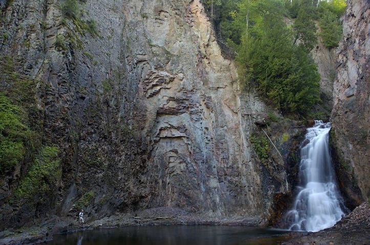
There is a 3/4 mil rail within the wayside. A great hike along the Caribou River leads to the base of Caribou Falls (35-foot waterfall), and also provides stunning views of Lake Superior and the Caribou River gorge. The wayside offers access to the Superior Hiking Trail.
6 paikallista suosittelee
Caribou Falls State Wayside
7232 MN-61(18-minute drive) 14.8 miles south on Highway 61 from Unit 6.
There is a 3/4 mil rail within the wayside. A great hike along the Caribou River leads to the base of Caribou Falls (35-foot waterfall), and also provides stunning views of Lake Superior and the Caribou River gorge. The wayside offers access to the Superior Hiking Trail.
(7-minute drive) 5.0 miles south of Unit 6.
Hidden Falls provides one of the easiest waterfalls to get to, just off Highway 61. The wayside stop is located 80 miles (128km) northeast of Duluth, and the falls are located on the west side of the highway, about 1/4 of a mile hike of the road. To the west, you can walk down the stairs out onto a bridge over the river to look down at rapids and out into the river spilling into Lake Superior.
Hidden Falls
(7-minute drive) 5.0 miles south of Unit 6.
Hidden Falls provides one of the easiest waterfalls to get to, just off Highway 61. The wayside stop is located 80 miles (128km) northeast of Duluth, and the falls are located on the west side of the highway, about 1/4 of a mile hike of the road. To the west, you can walk down the stairs out onto a bridge over the river to look down at rapids and out into the river spilling into Lake Superior.
(22-minute drive) 16.4 miles north on Highway 61 from Unit 6.
Discover the Cascades, a series of five waterfalls, and the Cascade Falls on a half-mile hike on the Cascade River Lower Loop.
♦ Explore over a mile of Lake Superior shoreline on the park's Lake Superior Shoreline Trail. Hike or cross-country ski this trail for scenic lake views.
♦ Relax under a grove of cedar trees at one of seven picnic sites along the Lake Superior shoreline.
(Parking is located a half-mile west of the park entrance on Highway 61.)
Cascade Falls
(22-minute drive) 16.4 miles north on Highway 61 from Unit 6.
Discover the Cascades, a series of five waterfalls, and the Cascade Falls on a half-mile hike on the Cascade River Lower Loop.
♦ Explore over a mile of Lake Superior shoreline on the park's Lake Superior Shoreline Trail. Hike or cross-country ski this trail for scenic lake views.
♦ Relax under a grove of cedar trees at one of seven picnic sites along the Lake Superior shoreline.
(Parking is located a half-mile west of the park entrance on Highway 61.)
(8-minute drive) 6.9 miles from Unit 6.
A well-kept secret falls. A great (very) short hike for your first night if you are running short on time.
Drive past the Lutsen Ski Resort, until the road turns to gravel, and then you will find parking along the left side. Park, then walk 120 feet further up the dirt road and the trail entrance will be on your left.
A brief 850-foot walk takes you to a bridge overlooking a waterfall on the Poplar River.
Poplar River
(8-minute drive) 6.9 miles from Unit 6.
A well-kept secret falls. A great (very) short hike for your first night if you are running short on time.
Drive past the Lutsen Ski Resort, until the road turns to gravel, and then you will find parking along the left side. Park, then walk 120 feet further up the dirt road and the trail entrance will be on your left.
A brief 850-foot walk takes you to a bridge overlooking a waterfall on the Poplar River.
(39-minute drive) 34 miles south on Highway 61 from Unit 6.
A roadside series of falls on the Beaver River. This is an easy waterfall to visit and is on the way to the many waterfalls along Minnesota's North Shore.
Beaver River Falls
(39-minute drive) 34 miles south on Highway 61 from Unit 6.
A roadside series of falls on the Beaver River. This is an easy waterfall to visit and is on the way to the many waterfalls along Minnesota's North Shore.
(9-minute drive) 5.2 miles south on Highway 61
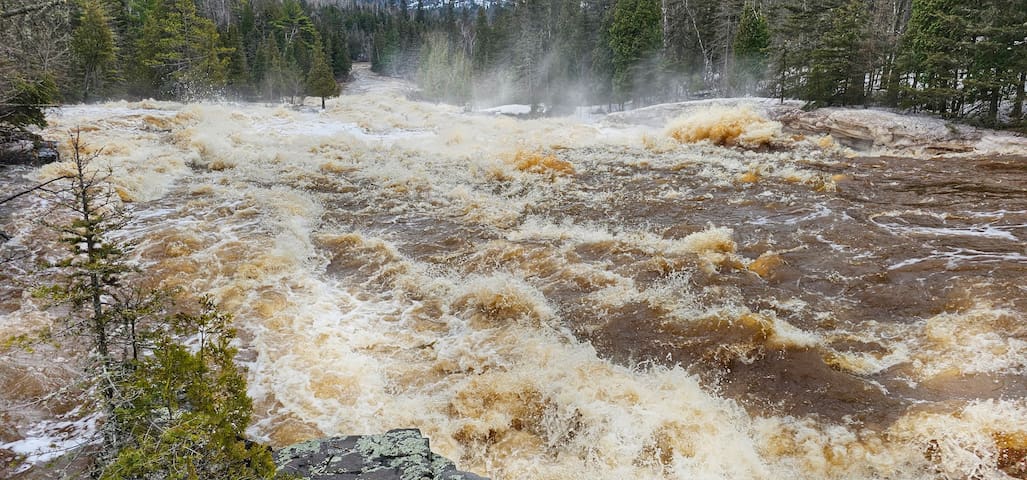
The Temperance River Gorge features a total of ten waterfalls as the river winds its way down Lake Superior.
21 paikallista suosittelee
Temperance River State Park
Temperance River State Park(9-minute drive) 5.2 miles south on Highway 61
The Temperance River Gorge features a total of ten waterfalls as the river winds its way down Lake Superior.
(30-minute drive) 26.6 miles south on Highway 61 from Unit 6.
This state park offers stunning views of sea caves, a sea stack, five waterfalls, and Palisade Head. View Lake Superior in all seasons. The park features the High Falls on the Baptism River, 63-feet tall.
39 paikallista suosittelee
Tettegouche State Park
5702 MN-61(30-minute drive) 26.6 miles south on Highway 61 from Unit 6.
This state park offers stunning views of sea caves, a sea stack, five waterfalls, and Palisade Head. View Lake Superior in all seasons. The park features the High Falls on the Baptism River, 63-feet tall.
(33-minute drive ) 20.6 miles. Head south on Highway 61.
The Cascades of the Manitou River is magnificent in its power, especially in the spring for beauty. You will likely encounter few people, though you may see a moose.
George Crosby Manitou State Park
7616 Co Hwy 7(33-minute drive ) 20.6 miles. Head south on Highway 61.
The Cascades of the Manitou River is magnificent in its power, especially in the spring for beauty. You will likely encounter few people, though you may see a moose.
(42-minute drive) 41.6 miles south on Hwy 61 from Unit 6.
From the parking area, there's a great five-mile hike up the west side of the river and around, a rare loop on the Superior Hiking Trail.
Split Rock River
(42-minute drive) 41.6 miles south on Hwy 61 from Unit 6.
From the parking area, there's a great five-mile hike up the west side of the river and around, a rare loop on the Superior Hiking Trail.
(45-minute drive) 44.8 miles south on Hwy 61 from Unit 6.
It is free to park here and see the multiple, large waterfalls.
It is a short walk to the Upper, Middle, and Lower Falls, and a hike to Fifth Falls. There are picnic grounds down by the lakeshore.
8 paikallista suosittelee
Gooseberry Falls
(45-minute drive) 44.8 miles south on Hwy 61 from Unit 6.
It is free to park here and see the multiple, large waterfalls.
It is a short walk to the Upper, Middle, and Lower Falls, and a hike to Fifth Falls. There are picnic grounds down by the lakeshore.
(32-minute drive) 27.7 miles south on Hwy 61 from Unit 6.
Illgen Falls is a gorgeous little waterfall in Tettegouche State Park.
Access to Illgen Falls is easy, at less than one mile north on County Highway 1 from the Tettegouche State Park Visitors Center, you will find a small drive on your left marked only with a brown gate that has a yellow sign that reads State Park on it. This can be difficult to find, so look for the first guardrail you will see on your left while driving from the County Highway 61 and County Highway 1 intersection toward Finland.
There is a small pullover next to this guardrail and the turn into the aforementioned drive is just past the guardrail. If the gate is closed you can park in the cut-out just before the gate and hike through the woods down to the falls. There is a well-maintained trail that will lead you right to the top of the waterfall.
7 paikallista suosittelee
Illgen Falls
(32-minute drive) 27.7 miles south on Hwy 61 from Unit 6.
Illgen Falls is a gorgeous little waterfall in Tettegouche State Park.
Access to Illgen Falls is easy, at less than one mile north on County Highway 1 from the Tettegouche State Park Visitors Center, you will find a small drive on your left marked only with a brown gate that has a yellow sign that reads State Park on it. This can be difficult to find, so look for the first guardrail you will see on your left while driving from the County Highway 61 and County Highway 1 intersection toward Finland.
There is a small pullover next to this guardrail and the turn into the aforementioned drive is just past the guardrail. If the gate is closed you can park in the cut-out just before the gate and hike through the woods down to the falls. There is a well-maintained trail that will lead you right to the top of the waterfall.
(9-minute drive) 6.4 miles south on Hwy 61 from Unit 6.
A lovely waterfall here right by the highway, best seen from the south side of the river.
At the mouth of the river, you will find Father Baraga's cross.
Cross River Falls
Minnesota 61(9-minute drive) 6.4 miles south on Hwy 61 from Unit 6.
A lovely waterfall here right by the highway, best seen from the south side of the river.
At the mouth of the river, you will find Father Baraga's cross.
(1 hr 24 minute drive) 80 miles south on Hwy 61
Lester River Falls is the ideal place to either start your waterfall adventures on your drive up, or finish your vacation, taking a break on the drive home.
Located just north of Duluth at 61st Avenue East and Superior Street, the Lester Park River is the perfect place to spend an afternoon walking the trails, having a picnic, and taking in nature’s beauty.
Lester River Bridge Historical Marker
(1 hr 24 minute drive) 80 miles south on Hwy 61
Lester River Falls is the ideal place to either start your waterfall adventures on your drive up, or finish your vacation, taking a break on the drive home.
Located just north of Duluth at 61st Avenue East and Superior Street, the Lester Park River is the perfect place to spend an afternoon walking the trails, having a picnic, and taking in nature’s beauty.
(45-Minute drive) 39.6 miles north on Hwy 61
There are three waterfalls here. The Lower, Upper, and Devil’s Kettle. You can take a quick trip to the Lower Falls, just a five-minute (but steep) trek.
To reach the Upper Falls and Devil’s Kettle, it is two miles round trip. Although this trail quality is pretty good, it is a strenuous hike; there are a LOT of stairs.
This waterfall is amazing and a must-see, if you are able to do steps. Pace yourself and rest on the benches if you need it.
This unique waterfall has sparked imaginations for decades. That’s because this waterfall, called the Devil’s Kettle, splits into two: one half of the river flows up to the edge of the falls and tumbles over, but the other half slips into a hole at the top of the falls and disappears into the earth.
18 paikallista suosittelee
Devil’s Kettle Falls
(45-Minute drive) 39.6 miles north on Hwy 61
There are three waterfalls here. The Lower, Upper, and Devil’s Kettle. You can take a quick trip to the Lower Falls, just a five-minute (but steep) trek.
To reach the Upper Falls and Devil’s Kettle, it is two miles round trip. Although this trail quality is pretty good, it is a strenuous hike; there are a LOT of stairs.
This waterfall is amazing and a must-see, if you are able to do steps. Pace yourself and rest on the benches if you need it.
This unique waterfall has sparked imaginations for decades. That’s because this waterfall, called the Devil’s Kettle, splits into two: one half of the river flows up to the edge of the falls and tumbles over, but the other half slips into a hole at the top of the falls and disappears into the earth.
(45-minute drive) 41.6-mile drive south on Hwy 61
There are nine major falls along 1.3 miles of this impressive stretch of the northern river. Some falls are only visible from high above the river, so spring—before the trees leaf out—is the perfect time for viewing. Some of the falls are seasonal and are reduced to just a trickle as the warmer weather takes hold and precipitation drops. The trailhead for the Split Rock River is on Highway 61, 2.5 miles west of Split Rock Lighthouse State Park entrance.
Split Rock River
(45-minute drive) 41.6-mile drive south on Hwy 61
There are nine major falls along 1.3 miles of this impressive stretch of the northern river. Some falls are only visible from high above the river, so spring—before the trees leaf out—is the perfect time for viewing. Some of the falls are seasonal and are reduced to just a trickle as the warmer weather takes hold and precipitation drops. The trailhead for the Split Rock River is on Highway 61, 2.5 miles west of Split Rock Lighthouse State Park entrance.
(33-minute drive) 27.4 miles north on Hwy 61
Barrier Falls is one of the best-kept secrets in Minnesota, featuring a beautiful 25-foot waterfall.
This waterfall does not have a published trail to it, so it will require work to get there. If you make it, you will have reached a waterfall very few people have ever seen which is amazing in this day and age. Be safe, and good luck!
Devils Track Falls State Wayside
Superior Hiking Trail(33-minute drive) 27.4 miles north on Hwy 61
Barrier Falls is one of the best-kept secrets in Minnesota, featuring a beautiful 25-foot waterfall.
This waterfall does not have a published trail to it, so it will require work to get there. If you make it, you will have reached a waterfall very few people have ever seen which is amazing in this day and age. Be safe, and good luck!
Local SECRET! (42 minutes) 36.8 miles One of the best-kept secrets on the Minnesota North Shore, Glenn Avon Falls, is especially impressive during the spring melt.
Directions:
1. Turn left onto MN-61 S and drive 34.0 mi
2. Turn right onto Lax Lake Rd and drive 1.6 mi
3. Turn left onto Airport Rd and drive exactly 1.22 miles
look for a small, unmarked pull-off on the left-hand side of the road (space for two cars).
47.266589, -91.345051
Glenn Avon Falls, Beaver Bay Township, MN 55616, Yhdysvallat
Local SECRET! (42 minutes) 36.8 miles One of the best-kept secrets on the Minnesota North Shore, Glenn Avon Falls, is especially impressive during the spring melt.
Directions:
1. Turn left onto MN-61 S and drive 34.0 mi
2. Turn right onto Lax Lake Rd and drive 1.6 mi
3. Turn left onto Airport Rd and drive exactly 1.22 miles
look for a small, unmarked pull-off on the left-hand side of the road (space for two cars).
47.266589, -91.345051